Montgomery, New York
Appearance
Montgomery, New York | |
|---|---|
 Town Hall, on Bracken Road | |
| Etymology: For Richard Montgomery | |
| Nickname: Transportation Hub of the Northeast | |
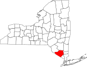
 Location in Orange County and the state of New York. | |
 Location of New York in the United States | |
| Coordinates: 41°31′N 74°12′W / 41.517°N 74.200°W | |
| Country | United States |
| State | New York |
| County | Orange |
| Founded | 1772 |
| Area | |
| • Total | 51.19 sq mi (132.58 km2) |
| • Land | 50.26 sq mi (130.16 km2) |
| • Water | 0.93 sq mi (2.42 km2) |
| Elevation | 410 ft (120 m) |
| Highest elevation | 820 ft (250 m) |
| Lowest elevation (Wallkill River at northern town line) | 240 ft (70 m) |
| Population | |
| • Total | 23,322 |
| • Density | 460/sq mi (180/km2) |
| Time zone | UTC-5 (EST) |
| • Summer (DST) | UTC-4 (EDT) |
| ZIP Codes | 12543, 12549, 12550, 12561, 12586, 12589 |
| Area code | 845 |
| FIPS code | 36-071-48153 |
| Website | Town website |
Montgomery is a town in Orange County, New York, United States. The population was 23,322 at the 2020 census.[2]
References
[change | change source]- ↑ "2016 U.S. Gazetteer Files". United States Census Bureau. Retrieved Jul 5, 2017.
- ↑ 2.0 2.1 "QuickFacts: Montgomery town, Orange County, New York". United States Census Bureau. Retrieved March 8, 2024.

