Morristown, Arizona
Appearance
Morristown, Arizona | |
|---|---|
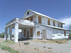
 Historic Morristown Hotel/Store-1899 Listed in the National Register of Historic Places | |
 Location in Maricopa County, Arizona | |
| Coordinates: 33°51′24″N 112°37′24″W / 33.85667°N 112.62333°W | |
| Country | United States |
| State | Arizona |
| County | Maricopa |
| Area | |
| • Total | 0.97 sq mi (2.52 km2) |
| • Land | 0.97 sq mi (2.52 km2) |
| • Water | 0.00 sq mi (0.00 km2) |
| Elevation | 1,988 ft (606 m) |
| Population | |
| • Total | 186 |
| • Density | 191.36/sq mi (73.88/km2) |
| Time zone | UTC-7 (Mountain (MST)) |
| ZIP code | 85342 |
| FIPS code | 04-47750 |
Morristown is a census-designated place in Maricopa County, Arizona, United States. It is about 50 miles (80 km) northwest of Phoenix.
References
[change | change source]- ↑ "2021 U.S. Gazetteer Files: Arizona". United States Census Bureau. Retrieved May 17, 2022.
- ↑ "Morristown CDP, Arizona: 2020 DEC Redistricting Data (PL 94-171)". U.S. Census Bureau. Retrieved May 17, 2022.


