Mount Pleasant, Pennsylvania
Appearance
Mount Pleasant, Pennsylvania | |
|---|---|
Borough | |
 Doughboy Statue West Main Street and Diamond Street | |
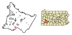
 Location of Mount Pleasant in Westmoreland County, Pennsylvania. | |
| Coordinates: 40°08′59″N 79°32′33″W / 40.14972°N 79.54250°W | |
| Country | United States |
| State | Pennsylvania |
| County | Westmoreland |
| Settled | 1797 |
| Incorporated | 1828 |
| Government | |
| • Type | Borough Council |
| Area | |
| • Total | 1.00 sq mi (2.59 km2) |
| • Land | 1.00 sq mi (2.59 km2) |
| • Water | 0.00 sq mi (0.00 km2) |
| Elevation | 1,171 ft (357 m) |
| Population | |
| • Total | 4,245 |
| • Density | 4,240.76/sq mi (1,637.20/km2) |
| Time zone | UTC−5 (Eastern (EST)) |
| • Summer (DST) | UTC−4 (EDT) |
| ZIP Code | 15666 |
| FIPS code | 42-51880 |
| Website | www.mtpleasantboro.com |
Mount Pleasant is a borough in Westmoreland County, Pennsylvania, United States. It is 45 miles (72 km) southeast of Pittsburgh. In the 2020 census, 4,245 people lived here.[2]
References
[change | change source]- ↑ "ArcGIS REST Services Directory". United States Census Bureau. Retrieved October 12, 2022.
- ↑ 2.0 2.1 "Profile of General Population and Housing Characteristics: 2020 Demographic Profile Data (DP-1): Mount Pleasant borough, Pennsylvania". United States Census Bureau. Retrieved March 12, 2024.

