Mutitjulu
Appearance
| Mutitjulu Northern Territory | |||||||||
|---|---|---|---|---|---|---|---|---|---|
 | |||||||||
| Coordinates | 25°21′03″S 131°03′59″E / 25.35083°S 131.06639°E | ||||||||
| Population | 296 (2011 census) | ||||||||
| Postcode(s) | 0872 | ||||||||
| Elevation | 523 m (1,716 ft) | ||||||||
| Location |
| ||||||||
| LGA(s) | MacDonnell Shire | ||||||||
| Territory electorate(s) | Namatjira | ||||||||
| Federal division(s) | Lingiari | ||||||||
| |||||||||
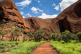
Muṯitjulu is an Indigenous Australian town in the Northern Territory. It is inside Uluṟu-Kata Tjuṯa National Park, just east of Uluṟu. It is named after a knee-shaped waterhole at the base of Uluṟu. Its people are mostly Pitjantjatjara. There are also some Yankunytjnatjara, Luritja and Ngaanyatjarra families living there. Almost everybody works in the national park.
The community had a population of 283 in the 2006 census.[1] It was reported to have dropped to around 150 in 2012, after alcohol was banned.[2]
References
[change | change source]- ↑ Australian Bureau of Statistics (25 October 2007). "Mutitjulu (Indigenous Area)". 2006 Census QuickStats. Retrieved 27 January 2012.
- ↑ Rothwell, Nicolas (4 August 2012). "Revolution's mosaic of success and failure". The Australian. Retrieved 27 November 2012.
Other websites
[change | change source]- Mutitjulu at WARU Archived 2005-02-16 at the Wayback Machine
- Mutijulu Community Council at ATNS Archived 2006-05-20 at the Wayback Machine

