New Stuyahok, Alaska
Appearance
New Stuyahok
Cetuyaraq | |
|---|---|
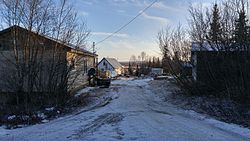
 A street level view of New Stuyahok, Alaska | |
| Coordinates: 59°27′7″N 157°18′44″W / 59.45194°N 157.31222°W | |
| Country | United States |
| State | Alaska |
| Census Area | Dillingham |
| Incorporated | November 20, 1972[1] |
| Area | |
| • Total | 35.95 sq mi (93.12 km2) |
| • Land | 33.72 sq mi (87.33 km2) |
| • Water | 2.24 sq mi (5.80 km2) |
| Elevation | 138 ft (42 m) |
| Population | |
| • Total | 512 |
| • Density | 15.19/sq mi (5.86/km2) |
| Time zone | UTC-9 (Alaska (AKST)) |
| • Summer (DST) | UTC-8 (AKDT) |
| ZIP code | 99636 |
| Area code | 907 |
| FIPS code | 02-53710 |
| GNIS feature ID | 1406972 |
New Stuyahok is a village in in the American state of Alaska. It is on the Nushagak River. In 2020 there were 512 people living in New Stuyahok.[3] The name Stuyahok means "going down river place".[4] In 2008 a new airport was built at a cost of $3,000,000.[5]
The village of New Stuyahok has been moved at least three times. It moved down the river from the first site in 1918. In 1942, new location of the village was said to be still too far up the river. Also, it was being flooded too often. This caused them to move village to its current location. A school and a post office were built in 1961.[4]
References
[change | change source]- ↑ "Directory of Borough and City Officials 1974". Alaska Local Government. XIII (2). Juneau: Alaska Department of Community and Regional Affairs: 57. January 1974.
- ↑ "2020 U.S. Gazetteer Files". United States Census Bureau. Retrieved October 29, 2021.
- ↑ 3.0 3.1 "New Stuyahok city, Alaska". United States Census Bureau. Retrieved September 7, 2023.
- ↑ 4.0 4.1 "The History of New Stuyahok, Alaska". ExploreNorth. Retrieved 7 September 2009.
- ↑ "Alaska State Budget" (PDF). Archived from the original (PDF) on 16 August 2009. Retrieved 7 September 2009.


