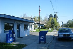
Nooksack, Washington
Appearance
Nooksack | |
|---|---|
 The local post office | |
 Location of Nooksack, Washington | |
| Coordinates: 48°55′42″N 122°19′10″W / 48.92833°N 122.31944°W | |
| Country | United States |
| State | Washington |
| County | Whatcom |
| Government | |
| • Type | Mayor–council[1] |
| Area | |
| • Total | 0.87 sq mi (2.25 km2) |
| • Land | 0.87 sq mi (2.25 km2) |
| • Water | 0.00 sq mi (0.00 km2) |
| Elevation | 85 ft (26 m) |
| Population | |
| • Total | 1,471 |
| • Density | 1,692.8/sq mi (653.6/km2) |
| Time zone | UTC-8 (Pacific (PST)) |
| • Summer (DST) | UTC-7 (PDT) |
| ZIP code | 98276 |
| Area code | 360 |
| FIPS code | 53-49275 |
| GNIS feature ID | 1507007[4] |
| Website | City of Nooksack |
Nooksack (/ˈnʊksæk/ NUUK-sak) is a city in Whatcom County, Washington, close to the border with Canada. The population was 1,471 at the 2020 census.[3]
References
[change | change source]- ↑ "Government". City of Nooksack. Retrieved April 2, 2022.
- ↑ "2020 U.S. Gazetteer Files". United States Census Bureau. Retrieved March 20, 2024.
- ↑ 3.0 3.1 "Profile of General Population and Housing Characteristics: 2020 Demographic Profile Data (DP-1): Nooksack city, Washington". United States Census Bureau. Retrieved March 20, 2024.
- ↑ "US Board on Geographic Names". United States Geological Survey. 2007-10-25. Retrieved 2008-01-31.
