Owens Lake
Appearance
| Owens Lake | |
|---|---|
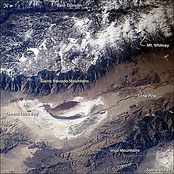
 Image of the Owens Valley from the International Space Station -- oriented top = true west. | |
| Location | Sierra Nevada Inyo County, California, USA |
| Coordinates | 36°26′00″N 117°57′03″W / 36.433269°N 117.950916°W |
| Type | Flat |
| Primary inflows | Owens River Natural springs and wells |
| Basin countries | United States |
| Max. length | 17.5 mi (28.2 km) |
| Max. width | 10 mi (16 km) |
| Max. depth | 3 ft (0.91 m) |
| Surface elevation | 3,556 ft (1,084 m) |
Owens Lake is a mostly dry lake in the eastern Sierra Nevada of Inyo County, California, located about 5 miles (8.0 km) south of Lone Pine, California. Unlike most dry lakes in the Basin and Range Province that have been dry for thousands of years, Owens held water until 1924. Today, some of the flow of the river has been restored, and the lake now has some water.
Wikimedia Commons has media related to Owens Lake.
