Pattan Kalan
Appearance
Pattan Kalan | |
|---|---|
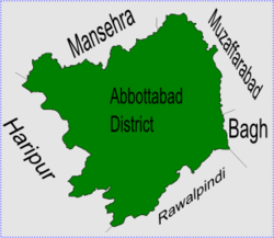
 Pattan Kalan is in Abbottabad District | |
| Coordinates: 34°N 73°E / 34°N 73°E | |
| Country | |
| Province | Khyber Pakhtunkhwa |
| District | Abbottabad |
| Tehsil | Abbottabad |
| Government | |
| • Nazim | Ali Akbar Qureshi[1] |
| • Naib Nazim | Muhammad Irshad Abbasi |
| Population | |
| • Total | 16,116 |
Pattan Kalan is one of the 51 Union Councils of Abbottabad District in the Khyber Pakhtunkhwa province of Pakistan.[2]
Location
[change | change source]Pattan Kalan is in the eastern edge of Abbottabad District and is next to Muzaffarabad District of Kashmir. It is also next the following Union Councils of Abbottabad District, Kukmang and Boi to the north, Kuthwal to the west, Beerangali and Nambal to the south
Subdivisions
[change | change source]The Union Council is subdivided into the following areas: Bandi Sararha, Banota, Chamiali, drair,Khokhriala, Larri, Sialkot,Dawatta , khoi , bagla
Maseena Kalan and Pattan Kalan.[1] Maseena Kalan is a big village.
References
[change | change source]- ↑ 1.0 1.1 Pattan Kalan Union Council[permanent dead link]
- ↑ "Administrative Units of District Abbottabad". Archived from the original on 2007-04-03. Retrieved 2008-08-01.
