Patuakhali
Appearance
Patuakhali
পটুয়াখালী | |
|---|---|
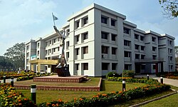
 Administration building of Patuakhali Science and Technology University | |
| Coordinates: 22°21′15″N 90°19′05″E / 22.3542°N 90.3181°E | |
| Country | |
| Division | Barisal |
| District | Patuakhali |
| Upazila | Patuakhali Sadar |
| Municipality Eshtablished | 1892 |
| Area | |
| • Total | 27.03 km2 (10.44 sq mi) |
| Population (2011) | |
| • Total | 65,000 |
| • Density | 2,400/km2 (6,200/sq mi) |
| Time zone | UTC+6 (BST) |
| Area code | 8600 |
| Website | patuakhali |
Patuakhali is a town in Bangladesh. It is the main town of Patuakhali District and sits on the southern bank of the Laukathi River in the Barisal division. Patuakhali is one of the oldest towns in the country. Its municipality was formed in 1892. The town has an area of 27.03 square kilometers and, according to the 2011 census, it had a population of 65,000.[1][2][3]
References
[change | change source]- ↑ "Patuakhali at a glance". Bangladesh National Information Desk. Archived from the original on 28 December 2016. Retrieved 18 December 2015.
- ↑ http://203.112.218.65:8008/WebTestApplication/userfiles/Image/PopCenZilz2011/Zila_Patuakhali.pdf. Archived (PDF) from the original on 2024-09-29. Retrieved 2024-09-29.
{{cite web}}: Missing or empty|title=(help) - ↑ http://203.112.218.65:8008/WebTestApplication/userfiles/Image/PopCen2011/COMMUNITY_Patuakhali.pdf. Archived (PDF) from the original on 2024-09-29. Retrieved 2024-09-29.
{{cite web}}: Missing or empty|title=(help)
