Pesaro
Pesaro | |
|---|---|
| Comune di Pesaro | |
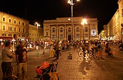
 Piazza del Popolo, Pesaro | |
 The comune Pesaro, in red, in the province of Pesaro and Urbino | |
| Coordinates: 43°55′N 12°54′E / 43.917°N 12.900°E | |
| Country | Italy |
| Region | Marche |
| Province | Pesaro e Urbino (PU) |
| Frazioni | see list |
| Government | |
| • Mayor | Matteo Ricci[1] |
| Area | |
| • Total | 126.77 km2 (48.95 sq mi) |
| Elevation | 11 m (36 ft) |
| Highest elevation | 320 m (1,050 ft) |
| Lowest elevation | 0 m (0 ft) |
| Population (January 2017)[3] | |
| • Total | 94,813 |
| • Density | 750/km2 (1,900/sq mi) |
| Demonym | Pesaresi |
| Time zone | UTC+1 (CET) |
| • Summer (DST) | UTC+2 (CEST) |
| Postal code | 61100 |
| Dialing code | 0721 |
| Patron saint | St. Terence |
| Saint day | 24 September |
| Website | Official website |
Pesaro is a city and comune in the Marche region, central Italy. It is the capital of the province of Pesaro and Urbino, on the Adriatic Sea. It is the second most populous city in the Marche, after Ancona.
Geography
[change | change source]Pesaro is on the coast of the Adriatic Sea. The city is between two small hills: the Monte Ardizio to the southeast, and the Colle San Bartolo to the northwest where is the Parco naturale regionale del Monte San Bartolo. The Foglia river flows through the city.
The comune of Pesaro has an area of 126.77 km2 (48.95 sq mi) and its altitude is 11 m (36 ft).[2]
Pesaro borders with the comuni Fano, Gabicce Mare, Gradara, Mombaroccio, Monteciccardo, Montelabbate, Tavullia and Vallefoglia (a small part).[4]
Frazioni
[change | change source]The following frazioni (hamlets) are part of Pesaroː
- Borgo Santa Maria
- Candelara
- Case Bruciate
- Casteldimezzo
- Cattabrighe
- Colombarone
- Fiorenzuola di Focara
- Ginestreto
- Novilara
- Ponte Valle
- Pozzo Alto
- Santa Maria dell'Arzilla
- Santa Marina
- Santa Veneranda
- Trebbiantico
- Tre Ponti
- Villa Ceccolini
- Villa Fastiggi
Population
[change | change source]There are 94,813 persons living in the comune in 2017,[3] for a population density of 747.9 inhabitants/km².
Evolution of the population

The people from this comune are known, in Italian, as pesaresi.
Twinned towns
[change | change source]Pesaro is twinned with:
Gallery
[change | change source]-
Palazzo Ducale
-
Duomo of Pesaro
-
Musei Civici, Pesaro
-
Monte Ardizio and beach
References
[change | change source]- ↑ "Comune di Pesaro- Sindaco" (in Italian). Portale Iztituzionale del Comune di Pesaro. Archived from the original on 2014-01-15. Retrieved 2 July 2016.
- ↑ 2.0 2.1 2.2 "Comune di Pesaro" (in Italian). Tuttitalia.it. Retrieved 2 July 2016.
- ↑ 3.0 3.1 "Statistiche demografiche ISTAT" (in Italian). Demo.istat.it. Archived from the original on 3 January 2018. Retrieved 2 November 2017.
- ↑ "Comuni limitrofi a Pesaro" (in Italian). Tuttitalia.it. Retrieved 2 July 2016.
Other websites
[change | change source]- Pesaro official website Archived 2004-09-28 at the Wayback Machine (in Italian)


