Plattsburg, Missouri
Appearance
Plattsburg, Missouri | |
|---|---|
 Clinton County Courthouse | |
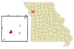
 Location of Plattsburg, Missouri | |
| Coordinates: 39°33′52″N 94°27′41″W / 39.56444°N 94.46139°W | |
| Country | United States |
| State | Missouri |
| County | Clinton |
| Founded | 1833 (as Concord, MO) 1835 (as Plattsburg, MO) |
| Government | |
| • Type | Mayor-Council |
| Area | |
| • Total | 3.63 sq mi (9.39 km2) |
| • Land | 3.60 sq mi (9.33 km2) |
| • Water | 0.03 sq mi (0.07 km2) |
| Elevation | 929 ft (283 m) |
| Population | |
| • Total | 2,222 |
| • Density | 617.05/sq mi (238.26/km2) |
| Time zone | UTC-6 (Central (CST)) |
| • Summer (DST) | UTC-5 (CDT) |
| ZIP code | 64477 |
| Area code | 816 |
| FIPS code | 29-58250 [4] |
| GNIS feature ID | 2396228[2] |
| Website | plattsburgmo.com |
Plattsburg is a city and county seat of Clinton County, Missouri and is part of the Kansas City metropolitan area within the United States.[5] As of the 2020 census, the city population was 2,222.[3]
References
[change | change source]- ↑ "ArcGIS REST Services Directory". United States Census Bureau. Retrieved August 28, 2022.
- ↑ 2.0 2.1 U.S. Geological Survey Geographic Names Information System: Plattsburg, Missouri
- ↑ 3.0 3.1 "Profile of General Population and Housing Characteristics: 2020 Demographic Profile Data (DP-1): Plattsburg city, Missouri". United States Census Bureau. Retrieved March 14, 2024.
- ↑ "U.S. Census website". United States Census Bureau. Retrieved 2008-01-31.
- ↑ "Find a County". National Association of Counties. Retrieved 2011-06-07.

