Porirua
Appearance
Porirua
Pari-ā-Rua | |
|---|---|
City | |
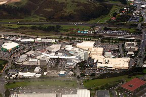
Top: Panoramic view of Porirua from Titahi Bay to Ranui Heights. Bottom: Aerial view of Porirua City Centre and Porirua Station (upper right) | |
| Motto(s): | |
 | |
| Coordinates: 41°08′S 174°51′E / 41.133°S 174.850°E | |
| Country | New Zealand |
| Region | Wellington |
| Wards |
|
| Electorates | Mana (general) Te Tai Hauāuru (Māori) |
| Government | |
| • Type | City council |
| • Mayor | Anita Baker |
| • Deputy mayor | Kylie Wihapi |
| • Territorial authority | Porirua City Council |
| • MPs | |
| Area | |
| • Territorial | 174.80 km2 (67.49 sq mi) |
| • Urban | 60.98 km2 (23.54 sq mi) |
| • Rural | 113.82 km2 (43.95 sq mi) |
| Population (June 2023) | |
| • Territorial | 62,400 |
| • Density | 360/km2 (920/sq mi) |
| Website | poriruacity |
Porirua (Māori: Pari-ā-Rua) is a city in the Wellington Region of New Zealand.
References
[change | change source]- ↑ https://web.archive.org/web/20160201192401/http://www.pcc.govt.nz/%2fAbout-Porirua%2fPorirua-s-heritage%2fPorirua-s-natural--cultural-and-historic-heritage%2fCivic-History%2fCoat-of-Arms Porirua City Council, 'Coat of Arms' (Archived)
- ↑ "Wards Maps and Boundaries". poriruacity.govt.nz. Archived from the original on 12 August 2022. Retrieved 8 August 2022.


