Providence, Rhode Island
Providence | |
|---|---|
State capital city | |
 | |
| Nickname(s): The Creative Capital, the Renaissance City, the Divine City, PVD, Prov | |
| Motto: "What Cheer?" | |
 Location in Rhode Island | |
| Coordinates: city(191,000) 41°49′25″N 71°25′20″W / 41.82361°N 71.42222°W | |
| Country | United States |
| State | Rhode Island |
| County | Providence |
| Region | New England |
| Settled | 1636 |
| Incorporated (city) | November 5, 1832 |
| Founded by | Roger Williams |
| Named for | Divine providence |
| Area | |
| • State capital city | 20.58 sq mi (53.31 km2) |
| • Land | 18.41 sq mi (47.67 km2) |
| • Water | 2.18 sq mi (5.64 km2) |
| Elevation | 10 ft (3 m) |
| Population | |
| • State capital city | 190,934 |
| • Rank | US: 134th |
| • Density | 10,373.47/sq mi (4,005.25/km2) |
| • Urban | 1,285,806 (US: 39th) |
| • Urban density | 2,362.5/sq mi (912.2/km2) |
| • Metro | 1,676,579 (US: 38th) |
| Time zone | UTC−5 (Eastern Time Zone) |
| • Summer (DST) | UTC−4 (EDT) |
| ZIP Codes | 02901–02912, 02918-02919, 02940 |
| Area code | 401 |
| FIPS code | 44-59000 |
| Website | www |
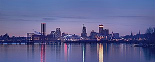
Providence is the capital and the most populous city of Rhode Island. It was one of the first cities established in the United States.[4] It is located in Providence County. It is the third largest city in the New England region. In the 2020 census, the city proper population was 190,934.[3] Providence has the 38th largest metropolitan population in the country, with an estimated metropolitan population of 1,676,579. This metropolitan area includes almost all of Rhode Island and part of Massachusetts.[5][6][7] Providence is at the mouth of the Providence River, at the head of Narragansett Bay. The city's small footprint is crisscrossed by streets at odd angles and has a rapidly changing distribution of residents.
Providence was founded in 1636 by Roger Williams, a religious exile from the Massachusetts Bay Colony. He named the area in honor of "God's merciful Providence" which he believed was responsible for revealing such a haven for him and his followers to settle. The official name of the state includes the name of the city, Rhode Island and Providence Plantations. After being one of the first cities in the country to industrialize, Providence became noted for its jewelry and silverware industry. Today, the City of Providence is home to eight hospitals and seven institutions of higher learning, which has shifted the city's economy into service industries, although it still retains significant manufacturing activity.
From colonial times to the mid-19th century, the Rhode Island General Assembly rotated meetings between the state's five county court houses. After 1853 the state legislature stopped meeting at the Kent, Washington and Bristol county courthouses, but continued to alternate its sessions between Providence State House and the Newport State House in Newport. Early in the 20th century, Providence became the only capital of the state.
Hurricanes
[change | change source]On September 21, 1938, a severe Category 3 hurricane struck Providence and nearby areas. Providence was flooded with storm surge.[8][9] Another hurricane hit the region in September 1944 near the Connecticut-Rhode Island border.[10] Ten years later, Hurricane Carol struck the area as a Category 2 hurricane, bringing severe storm surge and wind to the Providence area. The storm killed 17 in Rhode Island.[11]
Highways and Interstates
[change | change source]I-95 runs from north to south through Providence. I-195 connects the city to eastern Rhode Island and southeastern Massachusetts, including New Bedford, Massachusetts, and Cape Cod. I-295 encircles Providence while RI 146 provides a direct connection with Worcester, Massachusetts. The city's Iway project is moving I-195 to free up land and to reunify the Jewelry District with Downcity Providence. I-195 currently separates these two neighborhoods.[12] The project is estimated to cost $446 million and be completed in 2012.[13]
Colleges and Universities
[change | change source]
The flagship campuses of five of Rhode Island's colleges and universities are in Providence (city proper):
- Brown University, an Ivy League university and one of nine colonial colleges in the nation.
- Johnson & Wales University
- Providence College
- Rhode Island College, the state's oldest public college.
- Rhode Island School of Design (RISD)
References
[change | change source]- ↑ "ArcGIS REST Services Directory". United States Census Bureau. Retrieved October 12, 2022.
- ↑ U.S. Geological Survey Geographic Names Information System: Providence, Rhode Island
- ↑ 3.0 3.1 "Census Population API". United States Census Bureau. Retrieved Oct 12, 2022.
- ↑ "Providence: Introduction". Advameg, Inc. Retrieved 2007-06-05.
- ↑ "Population and Housing Occupancy Status: 2010 - United States -- Metropolitan Statistical Area; and for Puerto Rico more information 2010 Census National Summary File of Redistricting Data". 2010 United States Census. United States Census Bureau, Population Division. April 14, 2011. Retrieved 2011-06-07.
- ↑ "May 2006 OEC Metropolitan Statistical Area definitions". US Department of Labor. Retrieved 2007-06-09.
- ↑ "Population Estimates for Places over 100,000: 2000 to 2009". US Census Bureau. Retrieved 2009-08-30.
- ↑ "New England Hurricane 1938". NOAA. Retrieved July 14, 2018.
- ↑ "Hurricane of 1938". New England Today. Retrieved July 14, 2018.
- ↑ "Hurricanes". Rhode Island Climate Challenge. Archived from the original on June 28, 2018. Retrieved July 14, 2018.
- ↑ "Rhode Island Hurricanes". RI Hurricanes & Climate Change. Retrieved July 14, 2018.
- ↑ "Relocating I-195 in Providence". Rhode Island Department of Transportation. 2007. Archived from the original on 2009-02-28. Retrieved 2009-03-05.
- ↑ "195 Relocation Background". Providence College. Archived from the original on 2007-09-27. Retrieved 2007-05-26.


