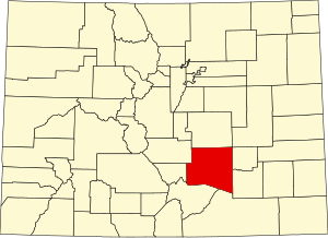
Pueblo County, Colorado
Appearance
Pueblo County | |
|---|---|
 The Pueblo County Courthouse with brass dome in Pueblo | |
 Location within the U.S. state of Colorado | |
 Colorado's location within the U.S. | |
| Coordinates: 38°09′N 104°31′W / 38.15°N 104.51°W | |
| Country | |
| State | |
| Founded | November 1, 1861 |
| Named for | City of Pueblo |
| Seat | Pueblo |
| Largest city | Pueblo |
| Area | |
| • Total | 2,398 sq mi (6,210 km2) |
| • Land | 2,386 sq mi (6,180 km2) |
| • Water | 12 sq mi (30 km2) 0.5% |
| Population | |
| • Total | 168,162 |
| • Density | 71/sq mi (27/km2) |
| Time zone | UTC−7 (Mountain) |
| • Summer (DST) | UTC−6 (MDT) |
| Website | county |
Pueblo County (/ˈpwɛbloʊ/ or /ˈpjɛbloʊ/) is a county in the state of Colorado in the United States. As of the 2020 census, 168,162 people lived there.[1] The county seat is Pueblo.
References
[change | change source]- ↑ 1.0 1.1 "QuickFacts: Pueblo County, Colorado". United States Census Bureau. Retrieved August 8, 2023.
