Rantoul, Illinois
Appearance
Rantoul | |
|---|---|
| The Corporate Village of Rantoul | |
 Downtown Rantoul | |
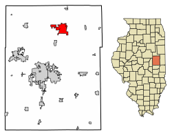
 Location of Rantoul in Champaign County, Illinois. | |
| Coordinates: 40°18′17″N 88°09′07″W / 40.30472°N 88.15194°W | |
| Country | United States |
| State | Illinois |
| County | Champaign |
| Townships | Rantoul and Ludlow |
| Founded | March 4, 1854 |
| Area | |
| • Total | 8.59 sq mi (22.26 km2) |
| • Land | 8.49 sq mi (21.99 km2) |
| • Water | 0.10 sq mi (0.27 km2) |
| Elevation | 745 ft (227 m) |
| Population | |
| • Total | 12,371 |
| • Density | 1,457.13/sq mi (562.58/km2) |
| Time zone | UTC-6 (CST) |
| • Summer (DST) | UTC-5 (CDT) |
| ZIP code | 61866[4] |
| Area codes | 217, 447 |
| FIPS code | 17-62783 |
| Website | www |
Rantoul is a village in Champaign County, Illinois, United States. Almost 12,000 people were living in Rantoul as of 2020. Rantoul has an area of 8.6 square miles.
References
[change | change source]- ↑ "2020 U.S. Gazetteer Files". United States Census Bureau. Retrieved March 15, 2022.
- ↑ "USGS detail on Newtown". Retrieved October 21, 2007.
- ↑ "QuickFacts: Rantoul village, Illinois". United States Census Bureau. Retrieved September 24, 2023.
- ↑ "Rantoul IL ZIP Code". zipdatamaps.com. 2023. Retrieved February 17, 2023.


