Ringsted
Appearance
Ringsted | |
|---|---|
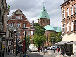
 Saint Bendt's Church (Skt. Bendts Kirke) in Ringsted, Denmark | |
| Coordinates: 55°26′33″N 11°47′24″E / 55.44250°N 11.79000°E | |
| Country | Denmark |
| Region | Zealand (Sjælland) |
| Municipality | Ringsted |
| Area | |
| • City | 295.48 km2 (114.09 sq mi) |
| Elevation | 54 m (177 ft) |
| Population (2015) | |
| • City | 21,866[1] |
| • Metro | 33,573 |
| Postal code | 4100 |
| Area code | (+45) 57 |
| Website | http://www.ringsted.dk/ |
Ringsted is a city in Denmark with a population of around 20,000.
Ringsted is about 60 km from the capital Copenhagen.
References
[change | change source]- ↑ BEF44: Population 1.January by urban areas, Danmarks Statistik, 2015, retrieved 1 January 2015


