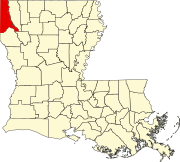
Rodessa, Louisiana
Appearance
Rodessa, Louisiana | |
|---|---|
| Village of Rodessa | |
 Interactive map of Rodessa | |
| Coordinates: 32°58′17″N 93°59′45″W / 32.97139°N 93.99583°W | |
| Country | |
| State | |
| Parish | Caddo |
| Government | |
| • Mayor | Paul W. Lockard (elected 2012) |
| Area | |
| • Total | 1.20 sq mi (3.12 km2) |
| • Land | 1.20 sq mi (3.12 km2) |
| • Water | 0.00 sq mi (0.00 km2) |
| Elevation | 230 ft (70 m) |
| Population | |
| • Total | 192 |
| • Rank | CD: 10th |
| • Density | 159.47/sq mi (61.57/km2) |
| Time zone | UTC-6 (CST) |
| • Summer (DST) | UTC-5 (CDT) |
| Area code | 318 |
| FIPS code | 22-65710 |
Rodessa is a village in Caddo Parish, Louisiana, United States.
References
[change | change source]- ↑ "2020 U.S. Gazetteer Files". United States Census Bureau. Retrieved March 20, 2022.
- ↑ "Profile of General Population and Housing Characteristics: 2020 Demographic Profile Data (DP-1): Rodessa village, Louisiana". United States Census Bureau. Retrieved March 3, 2024.

