
Rottenegg, Geisenfeld
Rottenegg | |
|---|---|
Village | |
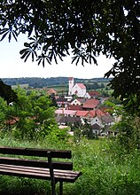
_Ortsansicht.JPG) View of Rottenegg | |
 Rottenegg Location in Bavaria | |
| Coordinates: 48°39′00″N 11°40′00″E / 48.65°N 11.666667°E | |
| Country | Germany |
| State | Bavaria |
| Region | Upper Bavaria |
| Municipality | Geisenfeld |
| Elevation | 428 m (1,404 ft) |
| Time zone | UTC+1 (CET) |
| • Summer (DST) | UTC+2 (CEST) |
| Postal code | 85290 |
Rottenegg is a village in the Hallertau of Bavaria, Germany. A past separate municipality, it is now part of the municipality of Geisenfeld in Pfaffenhofen.
Place[change | change source]
Rottenegg is in the Danube-Isar Hills of the Lower Bavarian Upland. The village is at 428 metres (1,404 ft) above sea level. It is 5.7 kilometres (3.5 mi) southeast of the Geisenfeld town center, and extends 1.1 kilometres (0.68 mi) in a northwest-southeast direction. Munich is 70 kilometres (43 mi) south of the village.
Gallery[change | change source]
-
 View of the village
 -
 Gravestone of General H. Lambert
 -
 Mountain church
_Ortsansicht2.JPG)
_General_Lampert_Grabst%C3%A4tte.JPG)
_Bergkirche.JPG)
References[change | change source]
| International | |
|---|---|
| National | |