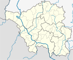
Saarlouis
Appearance
Saarlouis | |
|---|---|
 The Ludwigskirche (Saint Louis Church) | |
| Coordinates: 49°19′0″N 6°45′0″E / 49.31667°N 6.75000°E | |
| Country | Germany |
| State | Saarland |
| District | Saarlouis |
| Subdivisions | 8 |
| Government | |
| • Mayor | Roland Henz (SPD) |
| Area | |
| • Total | 43.27 km2 (16.71 sq mi) |
| Elevation | 181 m (594 ft) |
| Population (2022-12-31)[1] | |
| • Total | 34,717 |
| • Density | 800/km2 (2,100/sq mi) |
| Time zone | UTC+01:00 (CET) |
| • Summer (DST) | UTC+02:00 (CEST) |
| Postal codes | 66740 |
| Dialling codes | 06831 |
| Vehicle registration | SLS |
| Website | www |
Saarlouis is a town in the Saarland, Germany. It has 38,400 inhabitants. It is on the Saar. From 1936 to 1945 it was called Saarlautern. Ford Motor Company has a plant there; it produces the Focus, C-Max and Kuga.
References
[change | change source]- ↑ "Fläche und Bevölkerung - Stand: 31.12.2022 (Basis Zensus 2011)" (PDF) (in German). Statistisches Amt des Saarlandes. June 2023.
Other websites
[change | change source]![]() Media related to Saarlouis at Wikimedia Commons
Media related to Saarlouis at Wikimedia Commons


