San Fernando, Chile
Appearance
San Fernando | |
|---|---|
 City square of San Fernando | |
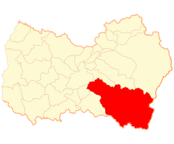
 Map of the commune of San Fernando in Region of O'Higgins | |
| Coordinates (city): 34°35′00″S 70°59′00″W / 34.5833°S 70.9833°W | |
| Country | Chile |
| Region | O'Higgins |
| Province | Colchagua |
| Government | |
| • Type | Municipality |
| • Alcalde | Juan Paulo Molina Contreras (PDC) |
| Area | |
| • Total | 2,441.3 km2 (942.6 sq mi) |
| Population (2002 Census)[2] | |
| • Total | 63,732 |
| • Density | 26/km2 (68/sq mi) |
| • Urban | 51,136 |
| • Rural | 12,596 |
| Sex | |
| • Men | 31,157 |
| • Women | 32,575 |
| Time zone | UTC-4 (CLT [3]) |
| • Summer (DST) | UTC-3 (CLST [4]) |
| Website | Municipality of San Fernando |
San Fernando (in English: Saint Ferdinand) is the capital of the province of Colchagua, in the central zone (central part) of Chile. San Fernando is the second most populated urban center of the Region of O'Higgins. It is located near to the Tinguiririca River, in the valley of Colchagua, San Fernando is 1,112 feet (339 m) above the level of the se. San Fernando was founded in 1742, and became the provincial capital in 1840.
Demography
[change | change source]According to the census of 2002, by the National Statistics Institute, San Fernando covers an area of 2,441.3 square kilometers, and has 63,732 inhabitants (31,157 men and 32,575 women).[2]
Sister cities
[change | change source]References
[change | change source]- ↑ (in Spanish) "Municipality of San Fernando". Retrieved 13 December 2010.
- ↑ 2.0 2.1 2.2 2.3 (in Spanish) "National Statistics Institute". Retrieved 13 December 2010.
- ↑ "Chile Time". WorldTimeZones.org. Archived from the original on 2007-09-11. Retrieved 2010-07-28.
- ↑ "Chile Summer Time". WorldTimeZones.org. Archived from the original on 2007-09-11. Retrieved 2010-07-28.
Other websites
[change | change source]Wikimedia Commons has media related to San Fernando, Chile.
- Municipality of San Fernando (in Spanish)


