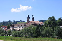
Sankt Peter, Baden-Württemberg
Appearance
St. Peter | |
|---|---|
 Abbey of St. Peter in the Black Forest | |
| Coordinates: 48°0′59″N 8°1′57″E / 48.01639°N 8.03250°E | |
| Country | Germany |
| State | Baden-Württemberg |
| Admin. region | Freiburg |
| District | Breisgau-Hochschwarzwald |
| Government | |
| • Mayor (2016–24) | Rudolf Schuler[1] (Ind.) |
| Area | |
| • Total | 35.93 km2 (13.87 sq mi) |
| Elevation | 716 m (2,349 ft) |
| Population (2022-12-31)[2] | |
| • Total | 2,721 |
| • Density | 76/km2 (200/sq mi) |
| Time zone | UTC+01:00 (CET) |
| • Summer (DST) | UTC+02:00 (CEST) |
| Postal codes | 79271 |
| Dialling codes | 07660 |
| Vehicle registration | FR |
| Website | www.st-peter-schwarzwald.de |
Sankt Peter is a municipality in Breisgau-Hochschwarzwald in Baden-Württemberg, Germany.
Geography
[change | change source]Location
[change | change source]St. Peter is a climatic spa within the Southern Black Forest Nature Park. It is on the southern flank of the Kandel and is about 12 miles east of Freiburg im Breisgau.
Localities
[change | change source]The municipality of St. Peter has the village of Bürgerschaft, the hamlet of Sägendobel, the settlements of Kandelberg, Neuwelt, Oberibental, Ränke, Rohr, Schmittenbach, Schönhöfe, Seelgut and Willmendobel and the farmsteads of Eckpeterhof, Langeck and Lindlehof.
History
[change | change source]The Abbey of St. Peter in the Black Forest was founded in 1093 by the Duke of Zähringen, Berthold II as his house abbey and family burial place. The abbey gradually developed around it.
References
[change | change source]- ↑ Aktuelle Wahlergebnisse, Staatsanzeiger, accessed 11 September 2021.
- ↑ "Bevölkerung nach Nationalität und Geschlecht am 31. Dezember 2022" [Population by nationality and sex as of December 31, 2022] (CSV) (in German). Statistisches Landesamt Baden-Württemberg. June 2023.
Other websites
[change | change source]Wikimedia Commons has media related to St. Peter (Hochschwarzwald).
- (in German) Official website
- (in German) St. Peter: History and images Archived 2008-12-08 at the Wayback Machine
- (in German) St. Peter


