Schwalm-Eder-Kreis
Appearance
(Redirected from Schwalm-Eder-Kreis Rural District)
Schwalm-Eder-Kreis | |
|---|---|
 | |
| Coordinates: 51°02′N 9°22′E / 51.033°N 9.367°E | |
| Country | Germany |
| State | Hesse |
| Capital | Homberg (Efze) |
| Area | |
| • Total | 1,538.46 km2 (594.00 sq mi) |
| Population (31 December 2022)[1] | |
| • Total | 182,595 |
| • Density | 120/km2 (310/sq mi) |
| Time zone | UTC+01:00 (CET) |
| • Summer (DST) | UTC+02:00 (CEST) |
| Vehicle registration | HR |
| Website | http://www.schwalm-eder-kreis.de |
Schwalm-Eder is a Kreis (district) in the north of Hesse, Germany.
Partnerships
[change | change source]The district has partnerships with
 Finland, Kajaani City,
 United Kingdom, district of Sedgemoor
 Poland, district of Piła and
 Russia, the Rayon ov (Yaroslavl Oblast).
Geography
[change | change source]The two rivers Schwalm and Eder gave the district its name.
Coat of arms
[change | change source]
|
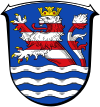
The coat of arms shows the lion of Hesse in the top. Below are wavy lines which symbolize the three main rivers in the district, Schwalm, Eder and Fulda. |
Towns and municipalities
[change | change source]| Towns | Municipalities | |
|---|---|---|
References
[change | change source]- ↑ "Bevölkerung in Hessen am 31.12.2022 nach Gemeinden" (XLS) (in German). Hessisches Statistisches Landesamt. June 2023.
Other websites
[change | change source]- Official website (in German)


