Songhua River
Appearance
| Songhua River Native Name: ᠰᡠᠩᡤᠠᡵᡳ ᡠᠯᠠ (sunggari ula) | |
|---|---|
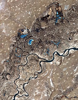
 Songhua River, just west of Harbin. Oxbow lakes are common sights along the sides of the river. | |
| Location | |
| Country | People's Republic of China |
| Provinces | Jilin, Heilongjiang |
| Physical characteristics | |
| Mouth | Amur |
| - location | Tongjiang, Heilongjiang |
| - coordinates | 47°41′56″N 132°31′03″E / 47.699°N 132.5176°E |
| Basin features | |
| Progression | Amur→ Sea of Okhotsk |
| Songhua River | |||||||
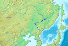
 Songhua River is shown in a darkish blue color. | |||||||
| Chinese name | |||||||
|---|---|---|---|---|---|---|---|
| Chinese | 松花江 | ||||||
| |||||||
| Alternative Chinese name | |||||||
| Chinese | 海西 | ||||||
| |||||||
| Manchu name | |||||||
| Manchu script | ᠰᡠᠩᡤᠠᡵᡳ ᡠᠯᠠ | ||||||
| Romanization | sunggari ula | ||||||
The Songhua River is one of the main rivers in China. It is about 1,434 kilometres (891 mi) long.
The river drains 557,180 square kilometres (215,130 sq mi) of land,[1][2] and has an annual discharge of 2,463 cubic metres per second (87,000 cu ft/s).[3]
References
[change | change source]- ↑ ), National Geographic Society (U.S (2008). National Geographic Atlas of China, p. 36. ISBN 9781426201363.
{{cite book}}:|last1=has numeric name (help) - ↑ "Amur river basin at Rivers Network". Archived from the original on 2019-09-07. Retrieved 2021-04-06.
- ↑ National Conditions: Main Rivers accessed October 21, 2010.
