Stark County, North Dakota
Appearance
Stark County | |
|---|---|
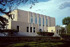
 Stark County Courthouse in Dickinson | |
 Location within the U.S. state of North Dakota | |
 North Dakota's location within the U.S. | |
| Coordinates: 46°49′N 102°40′W / 46.81°N 102.66°W | |
| Country | |
| State | |
| Founded | February 10, 1879 (created) May 25, 1883 (organized) |
| Named for | George Stark |
| Seat | Dickinson |
| Largest city | Dickinson |
| Area | |
| • Total | 1,340 sq mi (3,500 km2) |
| • Land | 1,335 sq mi (3,460 km2) |
| • Water | 5.5 sq mi (14 km2) 0.4% |
| Population (2020) | |
| • Total | 33,646 |
| • Density | 25/sq mi (9.7/km2) |
| Time zone | UTC−7 (Mountain) |
| • Summer (DST) | UTC−6 (MDT) |
| Congressional district | At-large |
| Website | www |
Stark County is a county located in the U.S. state of North Dakota. As of the 2020 census, 33,646 people lived there.[1] The county seat is Dickinson.
References
[change | change source]- ↑ "QuickFacts: Stark County, North Dakota". United States Census Bureau. Retrieved January 18, 2024.

