Subotica
Appearance
Subotica
Суботица | |
|---|---|
City | |
| Subotica | |
|
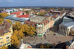
From top: Panorama of Subotica, City center, Reichel Palace, Subotica Synagogue, City hall, St. Theresa of Avila Cathedral, Monument to the Victims of Fascism | |
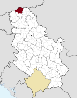
 Location of Subotica within Serbia | |
| Coordinates: 46°06′01″N 19°39′56″E / 46.10028°N 19.66556°E | |
| Country | Serbia |
| Province | Vojvodina |
| District | North Bačka |
| Settlements | 19 |
| Government | |
| • Mayor | Saša Vučinić (DS) |
| Area | |
| • Land | 1,008 km2 (389.2 sq mi) |
| Population (2011)[2] | |
| • City | 97,910[1] |
| • Urban | 105,681 |
| • Metro | 141,554[1] |
| Time zone | UTC+1 (CET) |
| • Summer (DST) | UTC+2 (CEST) |
| Postal code | 24000 |
| Area code | (+381) 24 |
| Car plates | SU |
| Website | www.subotica.rs |
Subotica (Serbian: Суботица [sǔbɔtit͡sa] (![]() listen)) is a city in northern Serbia. It is in the Autonomous Province of Vojvodina. It is the northern most city in Serbia.
listen)) is a city in northern Serbia. It is in the Autonomous Province of Vojvodina. It is the northern most city in Serbia.
The Serbian language is the most employed language in daily life, but Hungarian is also used by almost one third of the population in their daily conversations. Both languages are also widely employed in commercial and official signage [3]
References
[change | change source]- ↑ 1.0 1.1 http://pod2.stat.gov.rs/ObjavljenePublikacije/Popis2011/Knjiga20.pdf
- ↑ Popis stanovništva, domaćinstava i Stanova 2002. Knjiga 1: Nacionalna ili etnička pripadnost po naseljima (in Serbian). Statistical Office of the Republic of Serbia. 2003. ISBN 86-84433-00-9.
- ↑ "The Use of Hungarian and Serbian in the City of Szabadka/Subotica: An Empirical Study". Retrieved 2017-09-08.


