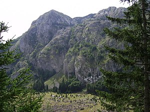
Sutjeska National Park
Appearance
| Sutjeska National Park | |
|---|---|
IUCN category II (national park) | |
 | |
| Location | Bosnia and Herzegovina |
| Nearest city | Foča |
| Coordinates | 43°20′N 18°41′E / 43.333°N 18.683°E |
| Area | 175 km2 (68 sq mi) |
| Established | 1962 |
The Sutjeska National Park is a national park in Bosnia and Herzegovina. It is in the Republika Srpska. Established in 1962, it is Bosnia and Herzegovina's oldest national park.
The park includes the highest mountain in Bosnia and Herzegovina, Maglić. The park covers an area of about 17,500 hectares (43,000 acres).
Perućica Forest Reserve is located within the park. It is 6 kilometres (3.7 mi) long, 1–3 kilometres (0.62–1.86 mi) wide, and has an area of 1,400 hectares (3,500 acres). It is a UNESCO recognized site. The forest has many trees that are 300 years old. It is a primeval forest.
Other websites
[change | change source]- Official website Archived 2017-10-27 at the Wayback Machine

