The Bottom
Appearance
The Bottom | |
|---|---|
 The Bottom, with the campus of the School of Medicine at the bottom right | |
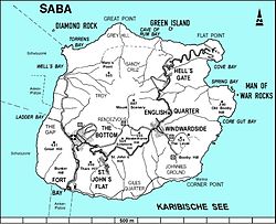
 Map of Saba showing The Bottom | |
| Coordinates: 17°37′34″N 63°14′57″W / 17.62611°N 63.24917°W | |
| Country | |
| Public body | |
| Population | |
| • Total | 462 |
| Time zone | UTC-4 (AST) |
| Climate | Aw |
The Bottom is the capital of the Caribbean island of Saba. In 2001, 462 people lived there.
The town was first called De Botte, which is old Dutch for "The Bowl". This is because the town made a bowl shape at the bottom of the mountains.
