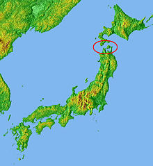
Tsugaru Strait


The Tsugaru Strait (津軽海峡, Tsugaru Kaikyō) is a channel that is between the islands of Honshu and Hokkaido in northern Japan. It connects the Sea of Japan with the Pacific Ocean.[1] It was named after the western part of Aomori Prefecture.
Geography
[change | change source]A warm current (Tsushima-kairyū) runs through the straight from the south to the north.[2]
Seikan Tunnel
[change | change source]The Seikan Tunnel passes under the strait at its narrowest point. This is between Tappi Misaki on the Tsugaru Peninsula in Aomori in Honshū and Shirakami Misaki on the Matsumae Peninsula in Hokkaidō.[1]
In the past, the most common way for passengers and freight to cross the strait was by a ferry. This was about a four-hour journey. However, in 1954, the Japanese ship Toya Maru sank in the Tsugaru Strait and many people died, this was because the weather was not good. This was another reason the people wanted the Seikan Tunnel to be made. [3]
References
[change | change source]- ↑ 1.0 1.1 Nussbaum, Louis-Frédéric. (2005). "Tsugaru Kaikyō" in Japan Encyclopedia, p. 998.
- ↑ Nussbaum, "Tsushima Kaikyō" at p. 1003.
- ↑ "Toya Maru ferry disaster | maritime disaster, near Hakodate, Japan [1954]". Encyclopedia Britannica. Retrieved 2021-03-10.
