Tsushima Strait

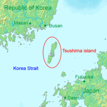
Tsushima Strait (対馬海峡, Tsushima Kaikyō), also known as the Korea Strait, is a narrow body of water between Japan and South Korea.[1] The name is used in two ways. It is used generally to describe the ocean area between Korea and Japan; and it also identifies the sea passage between the islands of Kyushu and Tsushima.[2]
The strait links the East China Sea and the Sea of Japan in the northwest Pacific Ocean.[3] Tsushima Island is between the western channel (Korea Strait) and the eastern channel (Tsushima Strait).[4]
Geography
[change | change source]Depending on usage, the northern shore of the strait is the eastern coast of the Korean peninsula or it may mean the eastern coast of Tsushima. The southern shores of the strait are the western coasts of Kyūshū and Honshū.
A warm current (Tsushima-kairyū) runs through the straight from south to north.[5]
Related pages
[change | change source]References
[change | change source]- ↑ The New York Times Guide to Essential Knowledge, 2nd ed., p. 609; Nussbaum, Louis-Frédéric. (2005). "Tsushima Kaikyō" in Japan Encyclopedia, p. 1003.
- ↑ US Department of State, "Limits in the Seas, No. 121; Straight Baseline and Territorial Sea Claims: South Korea," p. 23; retrieved 2012-9-4.
- ↑ Smith, Robert W. (1998). Island Disputes and the Law of the Sea: An Examination of Sovereignty and Delimitation Disputes, p. 27.
- ↑ Hong, Seoung-Yong. (2009). Maritime Boundary Disputes, Settlement Processes, and the Law of the Sea, p. 53.
- ↑ Nussbaum, p. 1003.
