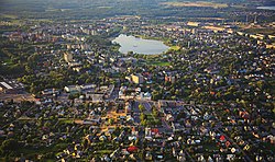
Utena
Appearance
Utena | |
|---|---|
City | |
| Utena | |
 | |
| Coordinates: 55°30′N 25°36′E / 55.500°N 25.600°E | |
| Country | |
| Ethnographic region | Aukštaitija |
| County | |
| Municipality | Utena district municipality |
| Eldership | Utena town eldership |
| Capital of | Utena district municipality Utena town eldership Utena rural eldership |
| First mentioned | 1261 |
| Granted city rights | 1599 |
| Government | |
| • Mayor | Alvydas Katinas |
| Area | |
| • City | 15.3 km2 (5.9 sq mi) |
| Elevation | 113 m (371 ft) |
| Population (2020) | |
| • City | 25,397 |
| • Density | 1,700/km2 (4,300/sq mi) |
| • Metro | 48,378 |
| Time zone | UTC+2 |
| • Summer (DST) | UTC+3 (EEST) |
| Postal code | 28xxx |
| Area code | (+370) 349 |
| Website | www |
Utena is a city in Lithuania. It is the administrative centre of Utena District and Utena County. Utena is one of the oldest cities in Lithuania.[1] The city's name most likely comes from a lake or river.
History
[change | change source]Utena was first mentioned in 1261, in a letter by Mindaugas to the Christ Knights.[1]
References
[change | change source]- ↑ 1.0 1.1 "Utenos miesto istorija". www.utena.lt. Archived from the original on 2021-04-30. Retrieved 2021-04-30.

