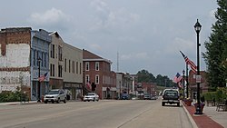
Vandalia, Illinois
Appearance
Vandalia | |
|---|---|
 | |
| Motto: "Oldest Existing Illinois Capital City" | |
 Location of Vandalia in Fayette County, Illinois. | |
 Location of Illinois in the United States | |
| Coordinates: 38°58′31″N 89°06′42″W / 38.97528°N 89.11167°W[1] | |
| Country | |
| State | |
| County | Fayette |
| Townships | Vandalia, Bear Grove, Sharon |
| Founded | 1819 |
| Area | |
| • Total | 8.16 sq mi (21.14 km2) |
| • Land | 8.15 sq mi (21.10 km2) |
| • Water | 0.02 sq mi (0.04 km2) |
| Elevation | 518 ft (158 m) |
| Population | |
| • Total | 7,458 |
| • Density | 915.43/sq mi (353.46/km2) |
| Time zone | UTC−6 (CST) |
| • Summer (DST) | UTC−5 (CDT) |
| ZIP Code | 62471 |
| Area code | 618 |
| FIPS code | 17-77317 |
| GNIS feature ID | 2397119[1] |
| Website | vandaliaillinois |
Vandalia is a city in Fayette County, Illinois, United States. It is 69 miles (111 km) northeast of St. Louis, on the Kaskaskia River. It was the capital of Illinois from 1819 to 1839. (The state legislature moved the capital from Kaskaskia to a more central location in Vandalia.) It was also the west end of the National (Cumberland) Road, which is now U.S. Highway 40. Today it is the county seat of Fayette County[4] and the home of the Vandalia State House State Historic Site (1836). The population was 7,458 at the 2020 census.[3]

References
[change | change source]- ↑ 1.0 1.1 1.2 U.S. Geological Survey Geographic Names Information System: Vandalia, Illinois
- ↑ "2020 U.S. Gazetteer Files". United States Census Bureau. Retrieved March 15, 2022.
- ↑ 3.0 3.1 "QuickFacts: Vandalia city, Illinois". United States Census Bureau. Retrieved September 23, 2023.
- ↑ "Find a County". National Association of Counties. Retrieved 2008-01-31.
