Weston-super-Mare
| Weston-super-Mare | |
|---|---|
 Weston-super-Mare bay and piers | |
| Location within Somerset | |
| Population | 76,143 (2011 Census)[1] |
| OS grid reference | ST320613 |
| Civil parish |
|
| Unitary authority | |
| Ceremonial county | |
| Region | |
| Country | England |
| Sovereign state | United Kingdom |
| Post town | WESTON-SUPER-MARE |
| Postcode district | BS22–BS24 |
| Dialling code | 01934 |
| Police | Avon and Somerset |
| Fire | Avon |
| Ambulance | South Western |
| UK Parliament | |
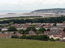
Weston-super-Mare, sometimes known as just Weston is a sea-side town Somerset, England. Weston is 18 miles (29 km) from the city of Bristol. It also includes the suburbs of Oldmixon, West Wick and Worle. The beach is a popular tourist destination. The town has many museums and a pier.
History
[change | change source]Iron age
[change | change source]The earliest settlements of Weston are iron age hill forts in the north
19th century
[change | change source]
By the time of the 19th century, Weston had already become a popular tourist destination
Modern history
[change | change source]in world war 2, 4,000 people migrated to weston-super-mare[source?]
Transport
[change | change source]Weston is connected to the M5 motorway by junction 21 where the dual carriageway A370 goes to the town centre.
The main railway station is on a short loop off the Bristol to Exeter line. The station is called Westo-super-Mare. It is close to the town centre and less than ten minutes walk from the sea front.
References
[change | change source]- ↑ "2011 Census Profile". North Somerset Council. Archived from the original (Excel) on 4 January 2014. Retrieved 4 January 2014.

