Woburn, Massachusetts
Appearance
Woburn, Massachusetts | |
|---|---|
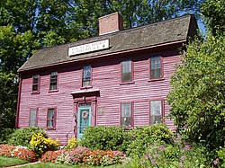
 Benjamin Thompson House, Woburn, Massachusetts | |
| Motto(s): Industria et Virtute (Latin) "Industry and Virtue" | |
 Location in Middlesex County, Massachusetts | |
| Coordinates: 42°28′45″N 71°09′10″W / 42.47917°N 71.15278°W | |
| Country | |
| State | |
| County | Middlesex |
| Region | New England |
| Settled | 1640 |
| Incorporated (town) | 1642 |
| Incorporated (city) | 1889 |
| Named for | Woburn, Bedfordshire |
| Government | |
| • Type | Mayor-council city |
| Area | |
| • Total | 12.94 sq mi (33.52 km2) |
| • Land | 12.65 sq mi (32.76 km2) |
| • Water | 0.29 sq mi (0.76 km2) |
| Elevation | 100 ft (30 m) |
| Population | |
| • Total | 40,876 |
| • Density | 3,231.30/sq mi (1,247.64/km2) |
| Time zone | UTC−5 (Eastern) |
| • Summer (DST) | UTC−4 (Eastern) |
| ZIP Codes | 01801, 01888 |
| Area code | 339/781 |
| FIPS code | 25-81035 |
| GNIS feature ID | 0612270 |
| Website | www.woburnma.gov |
Woburn (/ˈwuːbərn/ WOO-bərn) is a city in Middlesex County, Massachusetts, United States. The population was 40,876 at the 2020 census.[2] Woburn is located 9 miles (14 km) north of Boston.
References
[change | change source]- ↑ "2020 U.S. Gazetteer Files". United States Census Bureau. Retrieved May 21, 2022.
- ↑ 2.0 2.1 "QuickFacts: Woburn city, Massachusetts". United States Census Bureau. Retrieved March 5, 2024.


