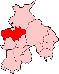
Wyre
Appearance
Borough of Wyre | |
|---|---|
Borough | |
 Shown within non-metropolitan Lancashire | |
| Coordinates: 53°54′00″N 2°48′32″W / 53.9000°N 2.8090°W | |
| Sovereign state | United Kingdom |
| Constituent country | England |
| Region | North West England |
| Ceremonial county | Lancashire |
| Founded | 1974 |
| Admin. HQ | Poulton-le-Fylde |
| Government | |
| • Type | Wyre Borough Council |
| • Leadership: | Leader & Cabinet |
| • Executive: | Conservative |
| • MPs: | Joan Humble, Michael Jack, Ben Wallace |
| Time zone | UTC+0 (Greenwich Mean Time) |
| • Summer (DST) | UTC+1 (British Summer Time) |
| ONS code | 30UQ |
| Ethnicity | 96.6% White 1.9% S.Asian[1] |
| Website | wyrebc.gov.uk |
Wyre is a local government district in Lancashire, England. It is a borough, based in the town of Poulton-le-Fylde. Wyre is named after the River Wyre, which runs through the district.
Wyre was formed in 1974.
Town and parish councils in Wyre
[change | change source]Urban areas
[change | change source]Parish councils
[change | change source]- Barnacre with Bonds
- Bleasdale
- Cabus
- Catterall
- Claughton on Brock
- Forton
- Garstang
- Great Eccleston
- Hambleton
- Inskip-with-Sowerby
- Kirkland, Lancashire
- Myerscough and Bilsborrow
- Nateby
- Nether Wyresdale
- Out Rawcliffe
- Pilling
- Preesall (Town Council)
- Stalmine-with-Staynall
- Upper Rawcliffe with Tarnacre
- Winmarleigh
References
[change | change source]- ↑ "Resident Population Estimates by Ethnic Group (Percentages)". Office for National Statistics. 30 October 2007. Archived from the original on 2018-12-26. Retrieved 2008-08-26.
Other websites
[change | change source]- Wyre Borough Council Archived 2006-08-04 at the Wayback Machine
