Xanten
Appearance
Xanten | |
|---|---|
 | |
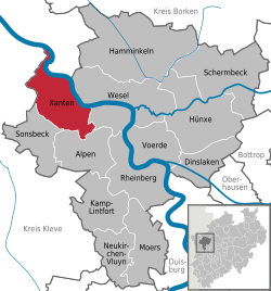
Location of Xanten within Wesel district | |
| Coordinates: 51°39′44″N 06°27′14″E / 51.66222°N 6.45389°E | |
| Country | Germany |
| State | North Rhine-Westphalia |
| Admin. region | Düsseldorf |
| District | Wesel |
| Subdivisions | 6 Stadtbezirke |
| Government | |
| • Mayor | Thomas Görtz (CDU) (CDU) |
| Area | |
| • Total | 72.39 km2 (27.95 sq mi) |
| Elevation | 50 m (160 ft) |
| Population (2022-12-31)[1] | |
| • Total | 21,582 |
| • Density | 300/km2 (770/sq mi) |
| Time zone | UTC+01:00 (CET) |
| • Summer (DST) | UTC+02:00 (CEST) |
| Postal codes | 46509 |
| Dialling codes | 0 28 01 und 0 28 04 (Marienbaum) |
| Vehicle registration | WES |
| Website | www |
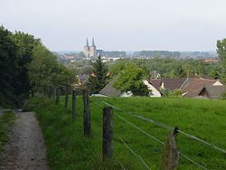
Xanten (Latin: Castra Vetera or Xantum) (IPA: ['ksantən]) is a historic town in Germany. It is in the Wesel district of the North Rhine-Westphalia state. Xanten is known for the Archaeological Park as well as its medieval picturesque city centre with Xanten Cathedral. About 800,000 tourists visit each year.
Xanten is the only German town whose name begins with "X".
References
[change | change source]Other websites
[change | change source]![]() Media related to Xanten at Wikimedia Commons
Media related to Xanten at Wikimedia Commons


