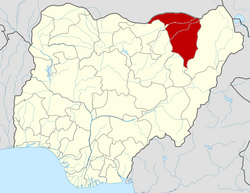
Yobe State
Appearance
Yobe | |
|---|---|
| Nicknames: | |
 Location of Yobe State in Nigeria | |
| Coordinates: 12°00′N 11°30′E / 12.000°N 11.500°E | |
| Country | |
| Date created | 27 August 1991 |
| Capital | Damaturu |
| Government | |
| • Governor (List) | Mai Mala Buni (APC) |
| • Deputy Governor | Idi Barde Gubana |
| • Senators |
|
| Area | |
| • Total | 45,502 km2 (17,568 sq mi) |
| • Rank | 6th of 36 |
| Population (2006 census) | |
| • Total | 2,321,339[1] |
| • Estimate (2011) | 2,757,000 |
| • Rank | 32nd of 36 |
| GDP (PPP) | |
| • Year | 2007 |
| • Total | $2.01 billion[2] |
| • Per capita | $843[2] |
| Time zone | UTC+01 (WAT) |
| postal code | 320001 |
| ISO 3166 code | NG-YO |
| HDI (2018) | 0.365[3] low · 35th of 37 |
Yobe is one of the 36 states of Nigeria. The capital is Damaturu. It was created on 27 August 1991.
Local government areas
[change | change source]The state consists of 17 local government areas including:
References
[change | change source]- ↑ "2006 PHC Priority Tables – NATIONAL POPULATION COMMISSION". population.gov.ng. Archived from the original on 2017-10-10. Retrieved 2017-10-10.
- ↑ 2.0 2.1 "C-GIDD (Canback Global Income Distribution Database)". Canback Dangel. Retrieved 2008-08-20.
- ↑ "Sub-national HDI - Area Database - Global Data Lab". hdi.globaldatalab.org. Retrieved 2018-09-13.
