Zwickauer Land Rural District
Appearance
Zwickauer Land | |
|---|---|
 | |
| Coordinates: 50°42′N 12°21′E / 50.7°N 12.35°E | |
| Country | Germany |
| State | Saxony |
| Adm. region | Chemnitz |
| Disbanded | 2008 |
| Capital | Werdau |
| Area | |
| • Total | 511.09 km2 (197.33 sq mi) |
| Population (2001) | |
| • Total | 133,741 |
| • Density | 260/km2 (680/sq mi) |
| Time zone | UTC+01:00 (CET) |
| • Summer (DST) | UTC+02:00 (CEST) |
| Vehicle registration | Z |
| Website | http://www.zwickauerland.de |
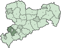
Zwickauer Land was a Landkreis (rural district) in the south-west of the Free State of Saxony, Germany. The independent city of Zwickau is in the middle of the district. It is nearly completely surrounded by the district. In July 2008, the city lost its right to administer itself, and become a city under the control of the district government.
The rural district was created on 1 August 1994. Its capital is Werdau. On January 1, 1999, the district was reorganised. Cainsdorf, Mosel, Oberrothenbach and Schlunzig were made a part of to Zwickau even though the people living in those towns wanted to stay independent.
Geography
[change | change source]The district is located in the Ore Mountains (Erzgebirge), with the main rivers being the Zwickauer Mulde and the Pleiße.
Coat of arms
[change | change source]
|
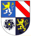
The coat of arms shows symbols of the old countries covered by the district. In the left-top is the lion of Pleißenland, created in the 12th century by emperor Frederick I. It symbolizes the complete district. The bars in the top-right are taken from the coat of arms of the family Schönburg, in the north-eastern part of the district. The black rose in the bottom-left is the symbol of the Wildenfels, for the east part of the district. The lion in the bottom-right is the symbol of the Vogt of Weida, showing the common history with the neighbouring Vogtland. |
Towns and municipalities
[change | change source]| Cities | Municipalities |
|---|---|
Other websites
[change | change source]- Official website (German, English)

