Chimborazo Province
Appearance
Chimborazo | |
|---|---|
Province | |
| Province of Chimborazo | |
 | |
 Chimborazo Province in Ecuador | |
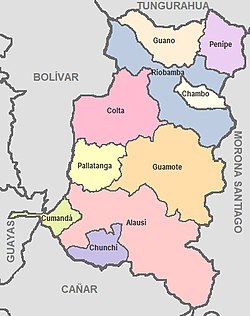
 Cantons of Chimborazo Province | |
| Country | Ecuador |
| Legal establishment | June 25, 1826 |
| Capital | Riobamba |
| Area | |
| • Total | 6,499.72 km2 (2,509.56 sq mi) |
| Population (2010 census) | |
| • Total | 458,581 |
| • Density | 71/km2 (180/sq mi) |
| Time zone | UTC-5 (ECT) |
| Vehicle registration | H |
| Website | www |
Chimborazo is a province in Ecuador. The capital is Riobamba.
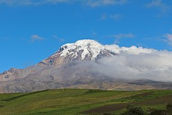
It is a home to a section of Sangay National Park. The province has Chimborazo (6,267 m), Ecuador's highest mountain.
Cantons
[change | change source]The province is divided into 10 cantons. The following table lists each with its population at the time of the 2001 census, its area in square kilometres (km²), and the name of the canton seat or capital.[1]
| Canton | Pop. (2001) | Area (km²) | Seat/Capital |
|---|---|---|---|
| Alausí | 45,230 | 1,644 | Alausí |
| Chambo | 13,300 | 163 | Chambo |
| Chunchi | 12,860 | 273 | Chunchi |
| Colta | 45,130 | 829 | Cajabamba |
| Cumandá | 17,470 | 159 | Cumandá |
| Guamote | 57,110 | 1,216 | Guamote |
| Guano | 48,080 | 460 | Guano |
| Pallatanga | 12,270 | 377 | Pallatanga |
| Penipe | 6,980 | 370 | Penipe |
| Riobamba | 261,360 | 980 | Riobamba |
References
[change | change source]- ↑ Cantons of Ecuador. Statoids.com. Retrieved 4 November 2009.

