Colfax, California
Appearance
Colfax, California | |
|---|---|
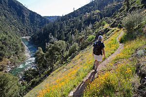
 The historic Stevens Trail's trailhead is in Colfax | |
 Location of Colfax in Placer County, California. | |
| Coordinates: 39°5′50″N 120°57′14″W / 39.09722°N 120.95389°W | |
| Country | |
| State | |
| County | Placer |
| Incorporated | February 23, 1910[1] |
| Named for | Schuyler Colfax |
| Area | |
| • Total | 1.41 sq mi (3.64 km2) |
| • Land | 1.41 sq mi (3.64 km2) |
| • Water | 0.00 sq mi (0.00 km2) |
| Elevation | 2,425 ft (739 m) |
| Population | |
| • Total | 1,995 |
| • Density | 1,419/sq mi (548/km2) |
| Time zone | UTC−8 (Pacific) |
| • Summer (DST) | UTC−7 (PDT) |
| ZIP Code | 95713 |
| Area code | 530 |
| FIPS code | 06-14498 |
| GNIS feature ID | 1655912 |
| Website | www |
Colfax (formerly, Alden Grove, Alder Grove, Illinoistown, and Upper Corral) is a city in Placer County, California. The population was 1,995 at the 2020 census.[4]
References
[change | change source]- ↑ "California Cities by Incorporation Date". California Association of Local Agency Formation Commissions. Archived from the original (Word) on November 3, 2014. Retrieved August 25, 2014.
- ↑ "2020 U.S. Gazetteer Files". United States Census Bureau. Retrieved October 30, 2021.
- ↑ "Colfax". Geographic Names Information System. United States Geological Survey. Retrieved November 4, 2014.
- ↑ 4.0 4.1 "Colfax city, California". United States Census Bureau. Retrieved July 31, 2023.


