Forest Park, Illinois
Appearance
Forest Park, Illinois (Harlem) | |
|---|---|
Village | |
 Madison Street, Downtown Forest Park | |
| Motto(s): "Big city access, small town charm" | |
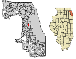
 Location of Forest Park in Cook County, Illinois. | |
 Location of Illinois in the United States | |
| Coordinates: 41°52′23″N 87°48′40″W / 41.87306°N 87.81111°W | |
| Country | United States |
| State | Illinois |
| County | Cook |
| Township | Proviso |
| Incorporated | 1907 |
| Government | |
| • Type | Commission |
| Area | |
| • Total | 2.40 sq mi (6.22 km2) |
| • Land | 2.40 sq mi (6.22 km2) |
| • Water | 0.00 sq mi (0.00 km2) 0% |
| Population | |
| • Total | 14,339 |
| • Density | 5,969.61/sq mi (2,305.18/km2) |
| ZIP code(s) | 60130 |
| Area code(s) | 708 |
| Geocode | 26935 |
| FIPS code | 17-26935 |
| Website | www |
| Demographics (2020)[2] | |||
|---|---|---|---|
| White | Black | Asian | Native |
| 49.6% | 30.9% | 6.2% | 0.4% |
| Islander | Other | Mixed | Hispanic (any race) |
| 0.02% | 4.7% | 8.1% | 11.3% |
Forest Park (formerly Harlem) is a village in Cook County, Illinois, a suburb of Chicago, United States. The population was 14,339 at the 2020 census.[2]
The Forest Park terminal on the CTA Blue Line is the line's western terminal, located on the Eisenhower Expressway at Des Plaines Avenue.[3]
References
[change | change source]- ↑ "2020 U.S. Gazetteer Files". United States Census Bureau. Retrieved March 15, 2022.
- ↑ 2.0 2.1 2.2 "DP1: PROFILE OF GENERAL POPULATION AND HOUSING CHARACTERISTICS". United States Census Bureau. Retrieved September 23, 2023.
- ↑ "Forest Park Terminal". Chicago L.org. Retrieved 9 December 2010.

