Kalchreuth
Appearance
Kalchreuth | |
|---|---|
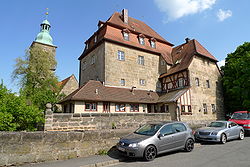
 Kalchreuth Castle | |
| Coordinates: 49°34′N 11°08′E / 49.567°N 11.133°E | |
| Country | Germany |
| State | Bavaria |
| Admin. region | Mittelfranken |
| District | Erlangen-Höchstadt |
| Government | |
| • Mayor (2020–26) | Herbert Saft[1] (FW) |
| Area | |
| • Total | 10.84 km2 (4.19 sq mi) |
| Elevation | 413 m (1,355 ft) |
| Population (2022-12-31)[2] | |
| • Total | 3,037 |
| • Density | 280/km2 (730/sq mi) |
| Time zone | UTC+01:00 (CET) |
| • Summer (DST) | UTC+02:00 (CEST) |
| Postal codes | 90562 |
| Dialling codes | 0911 |
| Vehicle registration | ERH |
| Website | www.kalchreuth.de |
Kalchreuth is a municipality in the district of Erlangen-Höchstadt, in Bavaria, Germany. It is 10 kilometers east of Erlangen and 15 kilometers north of Nuremberg and contains the villages of Kalchreuth, Käswasser and Röckenhof and also the hamlets of Stettenberg, Minderleinsmühle and Gabermühle.
Twin towns
[change | change source] La Chapelle-des-Fougeretz (France), since 1993
References
[change | change source]- ↑ Liste der ersten Bürgermeister/Oberbürgermeister in kreisangehörigen Gemeinden, Bayerisches Landesamt für Statistik, 15 July 2021.
- ↑ Genesis Online-Datenbank des Bayerischen Landesamtes für Statistik Tabelle 12411-003r Fortschreibung des Bevölkerungsstandes: Gemeinden, Stichtag (Einwohnerzahlen auf Grundlage des Zensus 2011) .


