Uttenreuth
Appearance
Uttenreuth | |
|---|---|
 Protestant Church of Saint Matthew | |
| Coordinates: 49°36′N 11°4′E / 49.600°N 11.067°E | |
| Country | Germany |
| State | Bavaria |
| Admin. region | Mittelfranken |
| District | Erlangen-Höchstadt |
| Municipal assoc. | Uttenreuth |
| Subdivisions | 2 districts |
| Government | |
| • Mayor (2020–26) | Frederic Ruth[1] |
| Area | |
| • Total | 5.93 km2 (2.29 sq mi) |
| Elevation | 291 m (955 ft) |
| Population (2022-12-31)[2] | |
| • Total | 5,070 |
| • Density | 850/km2 (2,200/sq mi) |
| Time zone | UTC+01:00 (CET) |
| • Summer (DST) | UTC+02:00 (CEST) |
| Postal codes | 91080 |
| Vehicle registration | ERH |
| Website | www.uttenreuth.de |
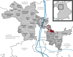
Uttenreuth is a town in the district of Erlangen-Höchstadt in Bavaria in Germany.
Geography
[change | change source]Geographical place
[change | change source]Uttenreuth is about 5-kilometer (3.1 mi) east of Erlangen in the Schwabach valley.
Neighboring communities
[change | change source]Towns neighboring Uttenreuth are Dormitz (in the East), Neunkirchen am Brand (Northeast), Marloffstein (North), Spardorf (Northwest) and Buckenhof in the West. To the South, Uttenreuth borders a large forest, the Sebalder Reichswald.
Subdivisions
[change | change source]- Uttenreuth
- Weiher (unified in 1978)
Literature
[change | change source]- Paulus, Erich and Regina Paulus. 2001. Uttenreuth - Geschichtsbuch über ein fränkisches Dorf am Rande der Stadt. ISBN 3-87707-576-2
References
[change | change source]- ↑ Liste der ersten Bürgermeister/Oberbürgermeister in kreisangehörigen Gemeinden, Bayerisches Landesamt für Statistik, 15 July 2021.
- ↑ Genesis Online-Datenbank des Bayerischen Landesamtes für Statistik Tabelle 12411-003r Fortschreibung des Bevölkerungsstandes: Gemeinden, Stichtag (Einwohnerzahlen auf Grundlage des Zensus 2011) .
Other websites
[change | change source]- Official website (German)


