County
|
FIPS code
|
County seat[1]
|
Created[2]
|
Formed from[2][3]
|
Meaning of name[2][3]
|
Population
(2020)[4]
|
Area[1]
|
Map
|
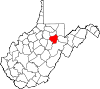
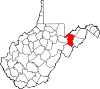
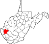
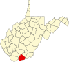
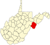
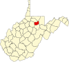
| Barbour County
|
001
|
Philippi |
1843 |
Harrison, Lewis, and Randolph counties |
Philip P. Barbour
(1783–1841)
United States Speaker of the House
(1821–23)
|
15,465
|
341 sq mi
(883 km2) |
|
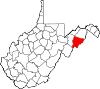
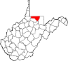
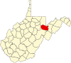
| Berkeley County
|
003
|
Martinsburg |
1772 |
Frederick County (Virginia) |
Norborne Berkeley
(1717–70)
Royal Governor of Virginia
(1768–70)
|
122,076
|
321 sq mi
(831 km2) |

|
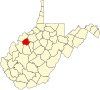
| Boone County
|
005
|
Madison |
1847 |
Cabell, Kanawha, and Logan counties |
Daniel Boone
(1734–1820)
American frontiersman
|
21,809
|
503 sq mi
(1,303 km2) |

|
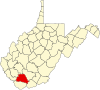
| Braxton County
|
007
|
Sutton |
1836 |
Kanawha, Lewis, and Nicholas counties |
Carter Braxton
(1736–97)
Signer of the Declaration of Independence
|
12,447
|
514 sq mi
(1,331 km2) |
|
| Brooke County
|
009
|
Wellsburg |
1796 |
Ohio County |
Robert Brooke
(1761–1800)
Governor of Virginia
(1794–96)
|
22,559
|
89 sq mi
(231 km2) |

|
| Cabell County
|
011
|
Huntington |
1809 |
Kanawha County |
William H. Cabell
(1772–1853)
Governor of Virginia
(1805–08)
|
94,350
|
282 sq mi
(730 km2) |
|
| Calhoun County
|
013
|
Grantsville |
1856 |
Gilmer County |
John C. Calhoun
(1782–1850)
United States Vice President
(1825–32)
|
6,229
|
281 sq mi
(728 km2) |
|
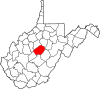
| Clay County
|
015
|
Clay |
1858 |
Braxton and Nicholas counties |
Henry Clay
(1777–1852)
United States Senator Kentucky
(1823–25)
United States Speaker of the House
(1849–52)
|
8,051
|
342 sq mi
(886 km2) |

|
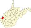
| Doddridge County
|
017
|
West Union |
1845 |
Harrison, Lewis, Ritchie, and Tyler counties |
Philip Doddridge
(1773–1832)
United States Congressman (Virginia)
(1829–32)
|
7,808
|
320 sq mi
(829 km2) |

|
| Fayette County
|
019
|
Fayetteville |
1831 |
Kanawha, Greenbrier, Logan, and Nicholas counties |
Marquis de Lafayette
(1757–1834)
French-born American Revolutionary War General
|
40,488
|
664 sq mi
(1,720 km2) |

|
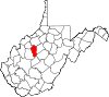
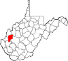
| Gilmer County
|
021
|
Glenville |
1845 |
Kanawha and Lewis counties |
Thomas Walker Gilmer
(1802–44)
United States Secretary of the Navy
(1844)
Governor of Virginia
(1840–41)
|
7,408
|
340 sq mi
(881 km2) |

|
| Grant County
|
023
|
Petersburg |
1866 |
Hardy County |
Ulysses S. Grant
(1822–85)
United States President
(1869–77)
|
10,976
|
477 sq mi
(1,235 km2) |
|
| Greenbrier County
|
025
|
Lewisburg |
1778 |
Montgomery County (Virginia) and Botetourt County (Virginia) |
Greenbrier River
|
32,977
|
1,021 sq mi
(2,644 km2) |
|
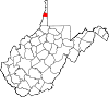
| Hampshire County
|
027
|
Romney |
1754 |
Augusta County (Virginia) and Frederick County (Virginia) |
County of Hampshire in England
|
23,093
|
642 sq mi
(1,663 km2) |

|
| Hancock County
|
029
|
New Cumberland |
1848 |
Brooke County |
John Hancock
(1737–93)
One of the Signers of the Declaration of Independence
Governor of Massachusetts
(1780–85)
and (1787–93)
|
29,095
|
83 sq mi
(215 km2) |

|
| Hardy County
|
031
|
Moorefield |
1786 |
Hampshire County |
Samuel Hardy
(1758–85)
Virginia delegate to the Continental Congress
(1783–85)
|
14,299
|
583 sq mi
(1,510 km2) |
|
| Harrison County
|
033
|
Clarksburg |
1784 |
Monongalia County |
Benjamin Harrison V
(1726–91)
Governor of Virginia
(1781–84)
|
65,921
|
416 sq mi
(1,077 km2) |
|
| Jackson County
|
035
|
Ripley |
1831 |
Kanawha, Mason, and Wood counties |
Andrew Jackson
(1767–1845)
United States President
(1829–37)
|
27,791
|
466 sq mi
(1,207 km2) |

|
| Jefferson County
|
037
|
Charles Town |
1801 |
Berkeley County |
Thomas Jefferson
(1743–1826)
United States President
(1801–09)
|
57,701
|
210 sq mi
(544 km2) |

|
| Kanawha County
|
039
|
Charleston |
1789 |
Greenbrier and Montgomery County (Virginia) |
Kanawha River
|
180,745
|
903 sq mi
(2,339 km2) |

|
| Lewis County
|
041
|
Weston |
1816 |
Harrison County |
Charles Lewis
(1736–74)
American Colonel killed at the
Battle of Point Pleasant[5]
|
17,033
|
389 sq mi
(1,008 km2) |

|
| Lincoln County
|
043
|
Hamlin |
1867 |
Boone, Cabell, Kanawha, and Putnam counties |
Abraham Lincoln
(1809–65)
United States President
(1861–65)
|
20,463
|
438 sq mi
(1,134 km2) |
|
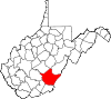
| Logan County
|
045
|
Logan |
1824 |
Cabell and Kanawha counties, Giles County (Virginia), and Tazewell County (Virginia) |
Chief Logan
(c.1723-80)
Mingo leader
|
32,567
|
454 sq mi
(1,176 km2) |

|
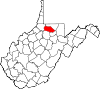
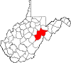
| Marion County
|
049
|
Fairmont |
1842 |
Harrison and Monongalia counties |
Francis Marion
(1732–95)
American Revolutionary War General
(1757–82)
|
56,205
|
310 sq mi
(803 km2) |
|
| Marshall County
|
051
|
Moundsville |
1835 |
Ohio County |
John Marshall
(1755–1835)
United States Secretary of State
(1800–01)
Chief Justice of the United States
(1801–35)
|
30,591
|
307 sq mi
(795 km2) |

|
| Mason County
|
053
|
Point Pleasant |
1804 |
Kanawha County |
George Mason
(1725–92)
United States Constitutional Convention
"Father of the Bill of Rights"
|
25,453
|
432 sq mi
(1,119 km2) |
|
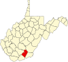
| McDowell County
|
047
|
Welch |
1858 |
Tazewell County (Virginia) |
James McDowell
(1795–1851)
Governor of Virginia
(1843–46)
|
19,111
|
535 sq mi
(1,386 km2) |
|
| Mercer County
|
055
|
Princeton |
1837 |
Giles County (Virginia) and Tazewell County (Virginia) |
Hugh Mercer
(1726–77)
American Revolutionary War General
(1775–76)
|
59,664
|
420 sq mi
(1,088 km2) |
|
| Mineral County
|
057
|
Keyser |
1866 |
Hampshire County |
abundant mineral resources
|
26,938
|
328 sq mi
(850 km2) |

|
| Mingo County
|
059
|
Williamson |
1895 |
Logan County |
Mingo Native Americans
|
23,568
|
423 sq mi
(1,096 km2) |
|
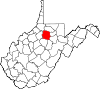
| Monongalia County
|
061
|
Morgantown |
1776 |
Augusta County (Virginia) |
Latin derivation for Monongahela River
|
105,822
|
361 sq mi
(935 km2) |
|
| Monroe County
|
063
|
Union |
1799 |
Greenbrier County |
James Monroe
(1758–1831)
United States Senator (Virginia)
(1790–94)
Governor of Virginia
(1799–1802)
and (1811)
United States President
(1817–25)
|
12,376
|
473 sq mi
(1,225 km2) |

|
| Morgan County
|
065
|
Berkeley Springs |
1820 |
Berkeley and Hampshire counties |
Daniel Morgan
(1736–1802)
United States Congressman (Virginia)
(1797–99)
|
17,063
|
229 sq mi
(593 km2) |

|
| Nicholas County
|
067
|
Summersville |
1818 |
Greenbrier, Kanawha, and Randolph counties |
Wilson Cary Nicholas
(1761–1820)
United States Senator (Virginia)
(1799–1804)
Governor of Virginia
(1814–16)
|
24,604
|
649 sq mi
(1,681 km2) |

|
| Ohio County
|
069
|
Wheeling |
1776 |
Augusta County (Virginia) |
Ohio River
|
42,425
|
106 sq mi
(275 km2) |
|
| Pendleton County
|
071
|
Franklin |
1788 |
Augusta County (Virginia), Rockingham County (Virginia), and Hardy |
Edmund Pendleton
(1721–1803)
First Continental Congress
(1774)
|
6,143
|
698 sq mi
(1,808 km2) |
|
| Pleasants County
|
073
|
Saint Marys |
1851 |
Ritchie, Tyler, and Wood counties |
James Pleasants, Jr.
(1769–1836)
United States Senator (Virginia)
(1819–22)
Governor of Virginia
(1822–25)
|
7,653
|
131 sq mi
(339 km2) |

|
| Pocahontas County
|
075
|
Marlinton |
1821 |
Bath County (Virginia), Pendleton, and Randolph |
Pocahontas
(c. 1595–1617)
Powhatan Native American who assisted early English settlers
|
7,869
|
940 sq mi
(2,435 km2) |

|
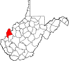
| Preston County
|
077
|
Kingwood |
1818 |
Monongalia County |
James Patton Preston
(1774–1843)
Governor of Virginia
(1816–19)
|
34,216
|
648 sq mi
(1,678 km2) |

|
| Putnam County
|
079
|
Winfield |
1848 |
Cabell, Kanawha, and Mason counties |
Israel Putnam
(1718–90)
American Revolutionary War General
|
57,440
|
346 sq mi
(896 km2) |
|
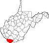
| Raleigh County
|
081
|
Beckley |
1850 |
Fayette County |
Sir Walter Raleigh
(1554–1618)
English explorer and poet
|
74,591
|
607 sq mi
(1,572 km2) |

|
| Randolph County
|
083
|
Elkins |
1787 |
Harrison County |
Edmund Jennings Randolph
(1753–1813)
Governor of Virginia
(1786–88)
First United States Attorney General
(1789–94)
|
27,932
|
1,040 sq mi
(2,694 km2) |
|
| Ritchie County
|
085
|
Harrisville |
1843 |
Harrison, Lewis, and Wood counties |
Thomas Ritchie
(1778–1854)
nationally influential Virginia newspaper publisher
|
8,444
|
454 sq mi
(1,176 km2) |

|
| Roane County
|
087
|
Spencer |
1856 |
Gilmer, Jackson, and Kanawha counties |
Spencer Roane
(1762–1822)
Virginia Supreme Court Justice
(1794–1822)
|
14,028
|
484 sq mi
(1,254 km2) |

|
| Summers County
|
089
|
Hinton |
1871 |
Fayette, Greenbrier, Mercer, and Monroe counties |
George W. Summers
(1804–68)
United States Congressman (Virginia)
(1843)
|
11,959
|
361 sq mi
(935 km2) |
|
| Taylor County
|
091
|
Grafton |
1844 |
Barbour, Harrison, Marion counties |
John Taylor of Caroline
(1753–1824)
United States Senator (Virginia)
(1792–94) and
(1803) and
(1822–24)
|
16,705
|
173 sq mi
(448 km2) |
|
| Tucker County
|
093
|
Parsons |
1856 |
Randolph County |
Henry St. George Tucker
(1780–1848)
United States Congressman (Virginia)
(1815–19)
Virginia Supreme Court
(1831–41)
|
6,762
|
419 sq mi
(1,085 km2) |
|
| Tyler County
|
095
|
Middlebourne |
1814 |
Ohio County |
John Tyler, Sr.
(1747–1813)
Governor of Virginia
(1808–11)
|
8,313
|
258 sq mi
(668 km2) |

|
| Upshur County
|
097
|
Buckhannon |
1851 |
Barbour, Lewis, and Randolph counties |
Abel Parker Upshur
(1790–1844)
United States Secretary of the Navy
(1841–43)
United States Secretary of State
(1843–44)
|
23,816
|
355 sq mi
(919 km2) |

|
| Wayne County
|
099
|
Wayne |
1842 |
Cabell County |
"Mad" Anthony Wayne
Major General
(1745–96)
American Revolutionary War
(1775–83)
and (1792–96)
United States Congressman Georgia
(1791)
|
38,982
|
506 sq mi
(1,311 km2) |

|
| Webster County
|
101
|
Webster Springs |
1860 |
Braxton, Nicholas, and Randolph counties |
Daniel Webster
(1782–1852)
United States Senator Massachusetts
(1827–41) and
(1845–50)
United States Secretary of State
(1841–53) and
(1850–52)
|
8,378
|
556 sq mi
(1,440 km2) |

|
| Wetzel County
|
103
|
New Martinsville |
1846 |
Tyler County |
Lewis Wetzel
(1763–1808)
noted frontiersman
|
14,442
|
359 sq mi
(930 km2) |

|
| Wirt County
|
105
|
Elizabeth |
1848 |
Jackson and Wood counties |
William Wirt
(1772–1834)
United States Attorney General
(1817–29)
|
5,194
|
233 sq mi
(603 km2) |
|
| Wood County
|
107
|
Parkersburg |
1798 |
Harrison County |
James Wood
(1741–1813)
Governor of Virginia
(1796–99)
|
84,296
|
367 sq mi
(951 km2) |

|
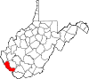
| Wyoming County
|
109
|
Pineville |
1850 |
Logan County |
derived from Lenape Native American term for "wide plain"
|
21,382
|
501 sq mi
(1,298 km2) |
|


