Péron, Ain
- العربية
- Arpetan
- Asturianu
- 閩南語 / Bân-lâm-gú
- Català
- Cebuano
- Deutsch
- English
- Español
- Esperanto
- Euskara
- فارسی
- Français
- Galego
- Հայերեն
- Bahasa Indonesia
- Italiano
- Kapampangan
- Kurdî
- Ladin
- Latina
- Lombard
- Magyar
- Malagasy
- مصرى
- Bahasa Melayu
- Nederlands
- Нохчийн
- Occitan
- Oʻzbekcha / ўзбекча
- Polski
- Português
- Română
- Русский
- Shqip
- Slovenčina
- Suomi
- Svenska
- Tagalog
- Basa Ugi
- Українська
- Vèneto
- Tiếng Việt
- Winaray
- 粵語
- Zazaki
- Zeêuws
- 中文
Appearance
From Simple English Wikipedia, the free encyclopedia
Péron | |
|---|---|
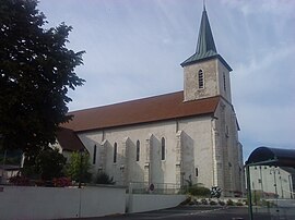
 Church of Saint Antoine | |
| Coordinates: 46°11′24″N 5°55′35″E / 46.19°N 5.9264°E / 46.19; 5.9264 | |
| Country | France |
| Region | Auvergne-Rhône-Alpes |
| Department | Ain |
| Arrondissement | Gex |
| Canton | Collonges |
| Intercommunality | Pays de Gex |
| Government | |
| • Mayor (2008–2014) | Christian Armand |
| Area 1 | 26.01 km2 (10.04 sq mi) |
| Population (2008) | 1,930 |
| • Density | 74/km2 (190/sq mi) |
| Time zone | UTC+01:00 (CET) |
| • Summer (DST) | UTC+02:00 (CEST) |
| INSEE/Postal code | 01288 /01630 |
| Elevation | 411–1,501 m (1,348–4,925 ft) (avg. 580 m or 1,900 ft) |
| 1 French Land Register data, which excludes lakes, ponds, glaciers > 1 km2 (0.386 sq mi or 247 acres) and river estuaries. | |
Péron is a commune. It is found in the region Auvergne-Rhône-Alpes in the Ain department in the east of France.


