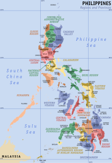
Regions of the Philippines
| Regions of the Philippines | |
|---|---|
 Administrative map of the Philippines | |
| Category | Region |
| Location | Philippines |
| Number | 18 (as of 2024) |
| Possible status | Administrative region Autonomous region |
| Populations | Smallest: 1,791,121 (CAR) Largest: 16,139,770 (Calabarzon) |
| Areas | Smallest: 636.00 km2 (245.56 sq mi) (NCR) Largest: 29,620.90 km2 (11,436.69 sq mi) (Mimaropa) |
| Government | Regional development council Metropolitan development authority Autonomous regional government |
| Subdivisions | Provinces Independent cities |
In the Philippines, regions (Filipino: rehiyon) are administrative divisions that serve primarily to organize the provinces (Filipino: lalawigan, probinsiya) of the country for administrative convenience. Most government offices are established by region instead of individual provincial offices, usually (but not always) in the city that is the regional center.
The regions themselves do not possess a separate local government, with the exception of the Bangsamoro Autonomous Region in Muslim Mindanao, which has an elected regional assembly and governor.
List of regions
[change | change source]The Philippines has 17 administrative regions. Fourteen of these regions are designated with numbers corresponding to their geographic location in order from north to south. The National Capital Region, Cordillera Administrative Region, and Autonomous Region in Muslim Mindanao do not have numerical designations.[1]
These regions are geographically combined into the three island groups of Luzon, Visayas, and Mindanao. Following is a list of the regions in their island groupings.
The regions CALABARZON, MIMAROPA, and SOCCSKSARGEN are written with upper case characters because they are acronyms that stand for their component provinces or cities. CALABARZON stands for CAvite, LAguna, BAtangas, Rizal and QueZON; MIMAROPA stands for Occidental and Oriental MIndoro, MArinduque, ROmblon and PAlawan; and SOCCSKSARGEN stands for SOuth Cotabato, Cotabato, Sultan Kudarat, SARangani and GENeral Santos.
| Island group: Luzon (Northern Philippines) | |||||||
| Map | Region (short name) |
Regional center | Provinces | Languages | Area (km2) | Population (2010)[1] |
Density (per km2) |
|---|---|---|---|---|---|---|---|

|
National Capital Region (NCR) |
Manila
|
- | Filipino | 636 | 11,855,975 | 18641.5 |

|
Cordillera (CAR) |
Baguio
|
Ilocano dialects | 18,294 | 1,616,867 | 88.4 | |

|
Ilocos (Region I) |
San Fernando, La Union
|
Ilocano Pangasinense |
12,840 | 4,748,372 | 369.8 | |

|
Cagayan Valley (Region II) |
Tuguegarao
|
Ilocano dialects | 26,838 | 3,229,163 | 120.3 | |

|
Central Luzon (Region III) |
San Fernando, Pampanga
|
Bulacan Tagalog Kapampangan |
21,470 | 10,137,737 | 472.2 | |

|
CALABARZON (Region IV-A) |
Calamba City
|
Tagalog |
16,229 | 12,609,803 | 777 | |

|
MIMAROPA (Region IV-B) |
Calapan
|
Batangas Tagalog Visayan Hilitribal |
27,456 | 2,744,671 | 100 | |

|
Bicol (Region V) |
Legazpi
|
Bicolano Masbateño |
17,632 | 5,420,411 | 307.4 | |
| Island group: Visayas (Central Philippines) | |||||||

|
Western Visayas (Region VI) |
Iloilo City
|
Aklanon Capiznon Karay-a Hiligaynon |
20,223 | 7,102,438 | 351.2 | |

|
Central Visayas (Region VII) |
Cebu City
|
Cebuano Boholano Negrense |
14,951 | 6,800,180 | 454.8 | |

|
Eastern Visayas (Region VIII) |
Tacloban
|
Waray Cebuano |
21,432 | 4,101,322 | 191.4 | |
| Island group: Mindanao (Southern Philippines) | |||||||

|
Zamboanga (Region IX) |
Pagadian
|
Mindanao Cebuano Chavacano |
14,811 | 3,407,353 | 230.1 | |

|
Northern Mindanao (Region X) |
Cagayan de Oro
|
Mindanao Cebuano Mindanao Hiligaynon |
17,125 | 4,297,323 | 250.9 | |

|
Davao (Region XI) |
Davao City
|
Davaoeño Cebuano Davaoeño Mindanao Cebuano |
20,244 | 4,468,563 | 220.7 | |

|
Cotabato (Region XII) |
Koronadal
|
Mindanao Hiligaynon Mindanao Cebuano |
18,433 | 4,109,571 | 222.9 | |

|
Caraga (Region XIII) |
Butuan
|
Mindanao Cebuano Surigaonon Kamayo |
18,847 | 2,429,224 | 128.9 | |

|
Bangsamoro (BARMM) |
Cotabato City
|
|
Maguindanaonon Tausug |
12,695 | 3,256,140 | 256.5 |
References
[change | change source]- ↑ 1.0 1.1 "NSCB ActiveStats - List of Regions". National Statistical Coordination Board - NSCB. Archived from the original on 27 October 2008. Retrieved 15 November 2013.
- ↑ 2.00 2.01 2.02 2.03 2.04 2.05 2.06 2.07 2.08 2.09 2.10 2.11 2.12 2.13 2.14 2.15 2.16 A highly urbanized city, one class of cities in the Philippines, independent from any province.
- ↑ 3.0 3.1 3.2 3.3 An independent component city, one class of cities in the Philippines that do not depend of any provincial government.
- ↑ "Philippines Tourists Guide". Pinay Wise. 2023-11-12. Retrieved 2024-05-04.
- ↑ A component city, part of the province of Basilan, but whose regional services are provided by the offices of Region IX.
Related pages
[change | change source]Other websites
[change | change source]- National Statistical Coordination Board Archived 2008-10-03 at the Wayback Machine
- National Statistics Office Archived 2013-10-04 at the Wayback Machine
