
Sanuki Province

Lua error in package.lua at line 80: module 'Module:Lang/data/is latn data' not found. was an old province of Japan in the area of Kagawa Prefecture on the island of Shikoku.[1] It was sometimes called Lua error in package.lua at line 80: module 'Module:Lang/data/is latn data' not found..
The province had borders with Awa and Iyo Provinces.
History
[change | change source]In the Meiji period, the provinces of Japan were converted into prefectures. The maps of Japan and Sanuki Province were reformed in the 1870s.[2]
Geography
[change | change source]Sanuki faced the Seto Inland Sea.
Shrines and Temples
[change | change source]Tamura jinja was the chief Shinto shrine (ichinomiya) of Sanuki. [3]
Gallery
[change | change source]-
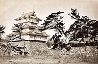 View of Takamatsu castle in Sanuki Province, photograph, 1882
 -
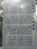 List of ichinomiya at Tamura Shrine which was the ichinomiya of Sanuki Province


Related pages
[change | change source]References
[change | change source]- ↑ Nussbaum, Louis-Frédéric. (2005). "Sanuki" in Japan Encyclopedia, p. 823.
- ↑ Nussbaum, "Provinces and prefectures" at p. 780.
- ↑ "Nationwide List of Ichinomiya," p. 3 Archived 2013-05-17 at the Wayback Machine; retrieved 2012-1-17.
Other websites
[change | change source]![]() Media related to Sanuki Province at Wikimedia Commons
Media related to Sanuki Province at Wikimedia Commons