Hudson County, New Jersey
Appearance
Hudson County | |
|---|---|
 View north on Hudson Waterfront | |
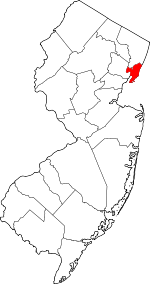
 Location within the U.S. state of New Jersey | |
 New Jersey's location within the U.S. | |
| Coordinates: 40°44′N 74°05′W / 40.73°N 74.08°W | |
| Country | |
| State | |
| Founded | 1840[1] |
| Named for | Henry Hudson |
| Seat | Jersey City[1] |
| Largest city | Jersey City (population and area) |
| Area | |
| • Total | 62.35 sq mi (161.5 km2) |
| • Land | 46.19 sq mi (119.6 km2) |
| • Water | 16.15 sq mi (41.8 km2) 25.9% |
| Population | |
| • Total | 724,854 |
| • Density | 15,691.5/sq mi (6,058.5/km2) |
| Congressional districts | 8th, 9th, 10th |
| Website | www |
Hudson County, a county in the U.S. state of New Jersey. It is west of the lower Hudson River, which was named for Henry Hudson.[4] The county seat is Jersey City.[5]
As of the 2020 census, the county's population was 724,854.[3]
References
[change | change source]- ↑ 1.0 1.1 National Association of Counties. "NACo County Explorer". Retrieved 12 January 2024.
- ↑ "2020 U.S. Gazetteer Files". United States Census Bureau. Retrieved January 12, 2024.
- ↑ 3.0 3.1 "QuickFacts: Hudson County, New Jersey". United States Census Bureau. Retrieved January 12, 2024.
- ↑ Kane, Joseph Nathan; and Aiken, Charles Curry. The American Counties: Origins of County Names, Dates of Creation, and Population Data, 1950-2000, p. 140. Scarecrow Press, 2005. ISBN 0810850362. Accessed January 21, 2013.
- ↑ New Jersey County Map, New Jersey Department of State. Accessed July 10, 2017.


